Weather Alert in California
Winter Storm Warning issued February 14 at 12:37PM PST until February 18 at 10:00PM PST by NWS Las Vegas NV
AREAS AFFECTED: Eastern Sierra Slopes of Inyo County
DESCRIPTION: * WHAT...Heavy snow possible. Total snow accumulations exceeding 3 feet above 8000 feet...1.5 to 2.5 feet above 7000 feet...and 8 to 16 inches down to 6000 feet. Winds could gust as high as 55 mph. * WHERE...Eastern Sierra Slopes. * WHEN...From 4 AM Monday to 10 PM PST Wednesday. * IMPACTS...Visibilities may drop below 1/4 mile due to falling and blowing snow. Travel could be very difficult to impossible. Strong winds could cause tree damage. * ADDITIONAL DETAILS...Snowfall rates will likely decrease for a period from late Monday night into Tuesday morning, only to increase once again by mid-day Tuesday.
INSTRUCTION: Persons are urged to stay indoors until conditions improve. If you must go outside, dress in layers. Several layers of clothes will keep you warmer than a single heavy coat. Cover exposed skin to reduce your risk of frostbite or hypothermia. Gloves, a scarf, and a hat will keep you from losing your body heat. Persons should consider delaying all travel. Motorists should use extreme caution if travel is absolutely necessary.
Want more detail? Get the Complete 7 Day and Night Detailed Forecast!
Current U.S. National Radar--Current
The Current National Weather Radar is shown below with a UTC Time (subtract 5 hours from UTC to get Eastern Time).

National Weather Forecast--Current
The Current National Weather Forecast and National Weather Map are shown below.

National Weather Forecast for Tomorrow
Tomorrow National Weather Forecast and Tomorrow National Weather Map are show below.

North America Water Vapor (Moisture)
This map shows recent moisture content over North America. Bright and colored areas show high moisture (ie, clouds); brown indicates very little moisture present; black indicates no moisture.

Weather Topic: What are Cumulus Clouds?
Home - Education - Cloud Types - Cumulus Clouds
 Next Topic: Drizzle
Cumulus clouds are fluffy and textured with rounded tops, and
may have flat bottoms. The border of a cumulus cloud
is clearly defined, and can have the appearance of cotton or cauliflower.
Cumulus clouds form at low altitudes (rarely above 2 km) but can grow very tall,
becoming cumulus congestus and possibly the even taller cumulonimbus clouds.
When cumulus clouds become taller, they have a greater chance of producing precipitation.
Next Topic: Drizzle
Weather Topic: What is Evaporation?
Home - Education - Precipitation - Evaporation
 Next Topic: Fog
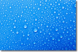
Evaporation is the process which returns water from the earth
back to the atmosphere, and is another crucial process in the water cycle.
Evaporation is the transformation of liquid into gas, and it happens because
molecules are excited by the application of energy and turn into vapor.
In order for water to evaporate it has to be on the surface of a body of water.
Next Topic: Fog
Current conditions powered by WeatherAPI.com


