Weather Alert in Alaska
Hydrologic Outlook issued August 25 at 2:05PM AKDT by NWS Fairbanks AK
AREAS AFFECTED: Howard Pass and the Delong Mountains; Central Brooks Range; Noatak Valley; Lower Kobuk Valley; Northern Seward Peninsula; Southern Seward Peninsula Coast; Interior Seward Peninsula; Eastern Norton Sound and Nulato Hills; Lower Yukon River; Lower Koyukuk Valley; Middle Yukon Valley; Lower Yukon and Innoko Valleys; Upper Koyukuk Valley; Dalton Highway Summits; Central Interior
DESCRIPTION: ESFAFG Moderate to heavy rainfall is expected to continue through Tuesday with recent rainfall totals of 1 to 3 inches in many areas of the middle Kuskokwim, middle and lower Yukon, Koyukuk, and Kobuk River basins. Additional rainfall of 1 to 2 inches are possible tonight and early Tuesday, especially at higher elevations. Expect increasing river levels on tributaries to these basins starting this evening with rising water levels on the main stems starting by mid-week.
INSTRUCTION: N/A
Want more detail? Get the Complete 7 Day and Night Detailed Forecast!
Current U.S. National Radar--Current
The Current National Weather Radar is shown below with a UTC Time (subtract 5 hours from UTC to get Eastern Time).

National Weather Forecast--Current
The Current National Weather Forecast and National Weather Map are shown below.

National Weather Forecast for Tomorrow
Tomorrow National Weather Forecast and Tomorrow National Weather Map are show below.

North America Water Vapor (Moisture)
This map shows recent moisture content over North America. Bright and colored areas show high moisture (ie, clouds); brown indicates very little moisture present; black indicates no moisture.

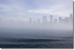
Weather Topic: What is Fog?
Home - Education - Cloud Types - Fog
 Next Topic: Fractus Clouds
Fog is technically a type of stratus cloud, which lies along the
ground and obscures visibility.
It is usually created when humidity in the air condenses into tiny water droplets.
Because of this, some places are more prone to foggy weather, such as regions
close to a body of water.
Fog is similar to mist; both are the appearance of water droplets suspended in
the air, but fog is the term applied to the condition when visibility is less than 1 km.
Next Topic: Fractus Clouds
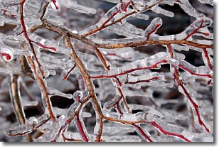
Weather Topic: What is Freezing Rain?
Home - Education - Precipitation - Freezing Rain
 Next Topic: Graupel
Freezing rain is a condition where precipitation which has fallen in the form of
water droplets reaches temperatures which are below freezing and freezes upon
coming into contact
with surface objects. The result of this precipitation is a glaze of ice which
can be damaging to plants and man-made structures. A severe onset of freezing
rain which results in a very thick glaze of ice is known as an ice storm.
Next Topic: Graupel
Current conditions powered by WeatherAPI.com


