Weather Alert in New York
Winter Weather Advisory issued February 9 at 12:55PM EST until February 11 at 7:00AM EST by NWS Burlington VT
AREAS AFFECTED: Northern St. Lawrence; Northern Franklin; Southeastern St. Lawrence; Southern Franklin; Western Clinton; Western Essex; Southwestern St. Lawrence
DESCRIPTION: * WHAT...Snow expected. Total snow accumulations between 3 and 6 inches. * WHERE...The St. Lawrence Valley and the northern Adirondacks. * WHEN...From 10 AM Tuesday to 7 AM EST Wednesday. * IMPACTS...The heaviest snowfall rates are expected to occur during the Tuesday evening commute and will likely increase impacts during this time. Roads, and especially bridges and overpasses, will likely become slick and hazardous. Plan on slippery road conditions. The hazardous conditions could also impact the Wednesday morning commute. * ADDITIONAL DETAILS...The heaviest snow will occur between 2 PM and 6 PM. Snowfall rates could exceed 1 to 1.5 inch per hour rates at times.
INSTRUCTION: Slow down and use caution while traveling. For the latest on road conditions in New York, visit https://511ny.org.
Want more detail? Get the Complete 7 Day and Night Detailed Forecast!
Current U.S. National Radar--Current
The Current National Weather Radar is shown below with a UTC Time (subtract 5 hours from UTC to get Eastern Time).

National Weather Forecast--Current
The Current National Weather Forecast and National Weather Map are shown below.

National Weather Forecast for Tomorrow
Tomorrow National Weather Forecast and Tomorrow National Weather Map are show below.

North America Water Vapor (Moisture)
This map shows recent moisture content over North America. Bright and colored areas show high moisture (ie, clouds); brown indicates very little moisture present; black indicates no moisture.

Weather Topic: What are Cirrus Clouds?
Home - Education - Cloud Types - Cirrus Clouds
 Next Topic: Condensation
Cirrus clouds are high-level clouds that occur above 20,000 feet
and are composed mainly of ice crystals.
They are thin and wispy in appearance.
What do they indicate?
They are often the first sign of an approaching storm.
Next Topic: Condensation
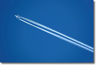
Weather Topic: What are Contrails?
Home - Education - Cloud Types - Contrails
 Next Topic: Cumulonimbus Clouds
A contrail is an artificial cloud, created by the passing of an
aircraft.
Contrails form because water vapor in the exhaust of aircraft engines is suspended
in the air under certain temperatures and humidity conditions. These contrails
are called exhaust contrails.
Another type of contrail can form due to a temporary reduction in air pressure
moving over the plane's surface, causing condensation.
These are called aerodynamic contrails.
When you can see your breath on a cold day, it is also because of condensation.
The reason contrails last longer than the condensation from your breath is
because the water in contrails freezes into ice particles.
Next Topic: Cumulonimbus Clouds
Current conditions powered by WeatherAPI.com


