Weather Alert in New York
Winter Weather Advisory issued February 9 at 12:55PM EST until February 11 at 7:00AM EST by NWS Burlington VT
AREAS AFFECTED: Eastern Clinton; Grand Isle; Western Franklin; Western Chittenden; Lamoille; Eastern Franklin; Eastern Chittenden; Eastern Addison; Eastern Rutland
DESCRIPTION: * WHAT...Snow expected. Total snow accumulations between 3 and 6 inches. * WHERE...The northern Champlain Valley and portions of the central and northern Green Mountains. * WHEN...From 2 PM Tuesday to 7 AM EST Wednesday. * IMPACTS...The heaviest snowfall rates are expected to occur during the Tuesday evening commute and will likely increase impacts during this time. Roads, and especially bridges and overpasses, will likely become slick and hazardous. Plan on slippery road conditions. The hazardous conditions could also impact the Wednesday morning commute. * ADDITIONAL DETAILS...The heaviest snow will occur between 5 PM and 9 PM. Snowfall rates could exceed 1 to 1.5 inch per hour rates at times.
INSTRUCTION: Slow down and use caution while traveling. For the latest on road conditions in Vermont, visit https://newengland511.org and for New York, visit https://511ny.org.
Want more detail? Get the Complete 7 Day and Night Detailed Forecast!
Current U.S. National Radar--Current
The Current National Weather Radar is shown below with a UTC Time (subtract 5 hours from UTC to get Eastern Time).

National Weather Forecast--Current
The Current National Weather Forecast and National Weather Map are shown below.

National Weather Forecast for Tomorrow
Tomorrow National Weather Forecast and Tomorrow National Weather Map are show below.

North America Water Vapor (Moisture)
This map shows recent moisture content over North America. Bright and colored areas show high moisture (ie, clouds); brown indicates very little moisture present; black indicates no moisture.

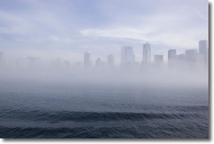
Weather Topic: What is Fog?
Home - Education - Cloud Types - Fog
 Next Topic: Fractus Clouds
Fog is technically a type of stratus cloud, which lies along the
ground and obscures visibility.
It is usually created when humidity in the air condenses into tiny water droplets.
Because of this, some places are more prone to foggy weather, such as regions
close to a body of water.
Fog is similar to mist; both are the appearance of water droplets suspended in
the air, but fog is the term applied to the condition when visibility is less than 1 km.
Next Topic: Fractus Clouds
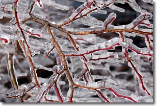
Weather Topic: What is Freezing Rain?
Home - Education - Precipitation - Freezing Rain
 Next Topic: Graupel
Freezing rain is a condition where precipitation which has fallen in the form of
water droplets reaches temperatures which are below freezing and freezes upon
coming into contact
with surface objects. The result of this precipitation is a glaze of ice which
can be damaging to plants and man-made structures. A severe onset of freezing
rain which results in a very thick glaze of ice is known as an ice storm.
Next Topic: Graupel
Current conditions powered by WeatherAPI.com


