Weather Alert in California
Winter Storm Warning issued February 14 at 11:51AM PST until February 18 at 10:00PM PST by NWS Reno NV
AREAS AFFECTED: Mono
DESCRIPTION: * WHAT...Heavy snow. Snow accumulations between 1 to 3 feet along and west of US395. Accumulations of 3 to 4 feet in the highest elevations along the Sierra crest. Lesser amounts of 2 to 4 inches for the Chalfant Valley. Winds gusting 35 to 45 mph, with up to 65 mph for wind prone locations along US395. Sierra ridge gusts over 100 mph. * WHERE...Mono County. * WHEN...From 10 PM Sunday to 10 PM PST Wednesday. * IMPACTS...Travel could be very difficult to impossible with periods of white out conditions. Very strong winds could cause damage to trees and power lines. * ADDITIONAL DETAILS...Conditions will rapidly deteriorate Monday evening with the highest snowfall rates anticipated Monday night through Tuesday evening.
INSTRUCTION: If you must travel, keep an extra flashlight, food, and water in your vehicle in case of an emergency. The latest road conditions for the state you are calling from can be obtained by calling 5 1 1.
Want more detail? Get the Complete 7 Day and Night Detailed Forecast!
Current U.S. National Radar--Current
The Current National Weather Radar is shown below with a UTC Time (subtract 5 hours from UTC to get Eastern Time).

National Weather Forecast--Current
The Current National Weather Forecast and National Weather Map are shown below.

National Weather Forecast for Tomorrow
Tomorrow National Weather Forecast and Tomorrow National Weather Map are show below.

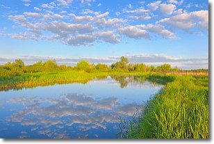
North America Water Vapor (Moisture)
This map shows recent moisture content over North America. Bright and colored areas show high moisture (ie, clouds); brown indicates very little moisture present; black indicates no moisture.

Weather Topic: What are Stratocumulus Clouds?
Home - Education - Cloud Types - Stratocumulus Clouds
 Next Topic: Stratus Clouds
Stratocumulus clouds are similar to altocumulus clouds in their
fluffy appearance, but have a slightly darker shade due to their additional mass.
A good way to distinguish the two cloud types is to hold your hand out and measure
the size of an individual cloud; if it is the size of your thumb it is generally
an altocumulus cloud, if it is the size of your hand it is generally a
stratocumulus cloud.
It is uncommon for stratocumulus clouds to produce precipitation, but if they do
it is usually a light rain or snow.
Next Topic: Stratus Clouds
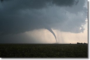
Weather Topic: What are Wall Clouds?
Home - Education - Cloud Types - Wall Clouds
 Next Topic: Altocumulus Clouds
A wall cloud forms underneath the base of a cumulonimbus cloud,
and can be a hotbed for deadly tornadoes.
Wall clouds are formed by air flowing into the cumulonimbus clouds, which can
result in the wall cloud descending from the base of the cumulonimbus cloud, or
rising fractus clouds which join to the base of the storm cloud as the wall cloud
takes shape.
Wall clouds can be very large, and in the Northern Hemisphere they generally
form at the southern edge of cumulonimbus clouds.
Next Topic: Altocumulus Clouds
Current conditions powered by WeatherAPI.com


