Weather Alert in Connecticut
Cold Weather Advisory issued February 8 at 8:47PM EST until February 9 at 10:00AM EST by NWS Albany NY
AREAS AFFECTED: Northern Litchfield; Southern Litchfield; Northern Berkshire; Southern Berkshire; Southern Herkimer; Southern Fulton; Montgomery; Northern Saratoga; Northern Washington; Schoharie; Western Schenectady; Eastern Schenectady; Southern Saratoga; Western Albany; Eastern Albany; Western Rensselaer; Eastern Rensselaer; Western Greene; Eastern Greene; Western Columbia; Eastern Columbia; Western Ulster; Eastern Ulster; Western Dutchess; Eastern Dutchess; Northern Fulton; Southeast Warren; Southern Washington; Bennington; Western Windham; Eastern Windham
DESCRIPTION: * WHAT...Very cold wind chills as low as 15 to 25 below with values as low as 25 to 29 below in the higher terrain areas of western New England, the Taconics, and the northern and eastern Catskills. * WHERE...Greater Capital District, Upper Hudson Valley, Mohawk Valley, the mid-Hudson Valley, northern and eastern Catskills, Helderbergs, Schoharie Valley, the Taconics and western New England. * WHEN...Until 10 AM EST Monday. * IMPACTS...The dangerously cold wind chills as low as 15 to 29 below zero could cause frostbite on exposed skin in as little as 10 to 30 minutes. Frostbite and hypothermia will occur if unprotected skin is exposed to these temperatures.
INSTRUCTION: Use caution while traveling outside. Wear appropriate clothing, a hat, and gloves. Keep pets indoors as much as possible.
Want more detail? Get the Complete 7 Day and Night Detailed Forecast!
Current U.S. National Radar--Current
The Current National Weather Radar is shown below with a UTC Time (subtract 5 hours from UTC to get Eastern Time).

National Weather Forecast--Current
The Current National Weather Forecast and National Weather Map are shown below.

National Weather Forecast for Tomorrow
Tomorrow National Weather Forecast and Tomorrow National Weather Map are show below.

North America Water Vapor (Moisture)
This map shows recent moisture content over North America. Bright and colored areas show high moisture (ie, clouds); brown indicates very little moisture present; black indicates no moisture.

Weather Topic: What is Hail?
Home - Education - Precipitation - Hail
 Next Topic: Hole Punch Clouds
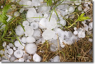
Hail is a form of precipitation which is recognized by large solid balls or
clumps of ice. Hail is created by thunderstorm clouds with strong updrafts of wind.
As the hailstones remain in the updraft, ice is deposited onto them until their
weight becomes heavy enough for them to fall to the earth's surface.
Hail storms can cause significant damage to crops, aircrafts, and man-made structures,
despite the fact that the duration is usually less than ten minutes.
Next Topic: Hole Punch Clouds
Weather Topic: What are Mammatus Clouds?
Home - Education - Cloud Types - Mammatus Clouds
 Next Topic: Nimbostratus Clouds
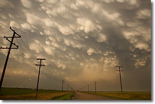
A mammatus cloud is a cloud with a unique feature which resembles
a web of pouches hanging along the base of the cloud.
In the United States, mammatus clouds tend to form in the warmer months, commonly
in the Midwest and eastern regions.
While they usually form at the bottom of a cumulonimbis cloud, they can also form
under altostratus, altocumulus, stratocumulus, and cirrus clouds. Mammatus clouds
warn that severe weather is close.
Next Topic: Nimbostratus Clouds
Current conditions powered by WeatherAPI.com


