Weather Alert in Oregon
Winter Storm Watch issued March 30 at 10:38PM PDT until April 2 at 5:00PM PDT by NWS Portland OR
AREAS AFFECTED: North Oregon Cascades; Cascades of Marion and Linn Counties; Cascades of Lane County
DESCRIPTION: * WHAT...Heavy snow possible. Total snow accumulations between 10 to 18 inches possible. Winds could gust as high as 35 mph. * WHERE...Northern and Central Oregon Cascades. * WHEN...From late Tuesday night through Thursday afternoon. * IMPACTS...Roads, and especially bridges and overpasses, will likely become slick and hazardous. * ADDITIONAL DETAILS...Latest guidance suggests the heaviest snow accumulations are forecast over the Cascades from Marion to Lane Counties. There is a 50-75% chance snowfall rates will occasionally exceed 1 inch/hour along the Cascade passes between 4 PM Wednesday and 8 AM Thursday, resulting in hazardous travel conditions due to a combination of low visibilities and accumulating snow.
INSTRUCTION: Winterize your vehicle and have a winter emergency driving kit readily available. Make sure your emergency kit has the following items: flashlights, batteries, blankets, a shovel, water, non-perishable food items, tire chains, etc. Now is a good time to put snow tires on your vehicle. Check on friends and family to see if they need help preparing. Monitor the latest forecasts and warnings for updates on this situation.
Want more detail? Get the Complete 7 Day and Night Detailed Forecast!
Current U.S. National Radar--Current
The Current National Weather Radar is shown below with a UTC Time (subtract 5 hours from UTC to get Eastern Time).

National Weather Forecast--Current
The Current National Weather Forecast and National Weather Map are shown below.

National Weather Forecast for Tomorrow
Tomorrow National Weather Forecast and Tomorrow National Weather Map are show below.

North America Water Vapor (Moisture)
This map shows recent moisture content over North America. Bright and colored areas show high moisture (ie, clouds); brown indicates very little moisture present; black indicates no moisture.

Weather Topic: What is Sleet?
Home - Education - Precipitation - Sleet
 Next Topic: Snow
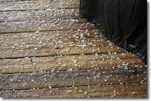
Sleet is a form of precipitation in which small ice pellets are the primary
components. These ice pellets are smaller and more translucent than hailstones,
and harder than graupel. Sleet is caused by specific atmospheric conditions and
therefore typically doesn't last for extended periods of time.
The condition which leads to sleet formation requires a warmer body of air to be
wedged in between two sub-freezing bodies of air. When snow falls through a warmer
layer of air it melts, and as it falls through the next sub-freezing body of air
it freezes again, forming ice pellets known as sleet. In some cases, water
droplets don't have time to freeze before reaching the surface and the result is
freezing rain.
Next Topic: Snow
Weather Topic: What are Stratocumulus Clouds?
Home - Education - Cloud Types - Stratocumulus Clouds
 Next Topic: Stratus Clouds
Stratocumulus clouds are similar to altocumulus clouds in their
fluffy appearance, but have a slightly darker shade due to their additional mass.
A good way to distinguish the two cloud types is to hold your hand out and measure
the size of an individual cloud; if it is the size of your thumb it is generally
an altocumulus cloud, if it is the size of your hand it is generally a
stratocumulus cloud.
It is uncommon for stratocumulus clouds to produce precipitation, but if they do
it is usually a light rain or snow.
Next Topic: Stratus Clouds
Current conditions powered by WeatherAPI.com


