Weather Alert in Montana
Winter Weather Advisory issued February 15 at 12:24PM MST until February 17 at 5:00PM MST by NWS Great Falls MT
AREAS AFFECTED: East Glacier Park Region; Southern Rocky Mountain Front; Upper Blackfoot and MacDonald Pass; Elkhorn and Boulder Mountains; Northwest Beaverhead County
DESCRIPTION: * WHAT...Snow expected. Total snow accumulations between 2 and 5 inches at pass level, with up to 7 inches at mountain peaks. * WHERE...The Continental Divide along the Rocky Mountain Front, Upper Blackfoot and MacDonald Pass, Elkhorn and Boulder Mountains, and Northwest Beaverhead County. * WHEN...From 2 AM to 5 PM MST Tuesday. * IMPACTS...Plan on slippery road conditions. Areas of blowing snow possible.
INSTRUCTION: Slow down and use caution while traveling. The latest road conditions can be obtained by calling 5 1 1 or visiting the MDT Road Report website. To see a graphical representation of the degree of stress on young livestock please visit our webpage and select Local Programs then Cold Air Advisory for Newborn Livestock.
Want more detail? Get the Complete 7 Day and Night Detailed Forecast!
Current U.S. National Radar--Current
The Current National Weather Radar is shown below with a UTC Time (subtract 5 hours from UTC to get Eastern Time).

National Weather Forecast--Current
The Current National Weather Forecast and National Weather Map are shown below.

National Weather Forecast for Tomorrow
Tomorrow National Weather Forecast and Tomorrow National Weather Map are show below.

North America Water Vapor (Moisture)
This map shows recent moisture content over North America. Bright and colored areas show high moisture (ie, clouds); brown indicates very little moisture present; black indicates no moisture.

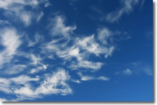
Weather Topic: What are Altostratus Clouds?
Home - Education - Cloud Types - Altostratus Clouds
 Next Topic: Cirrocumulus Clouds
Altostratus clouds form at mid to high-level altitudes
(between 2 and 7 km) and are created by a warm, stable air mass which causes
water vapor
to condense as it rise through the atmosphere. Usually altostratus clouds are
featureless sheets characterized by a uniform color.
In some cases, wind punching through the cloud formation may give it a waved
appearance, called altostratus undulatus. Altostratus clouds
are commonly seen with other cloud formations accompanying them.
Next Topic: Cirrocumulus Clouds
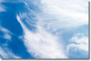
Weather Topic: What are Cirrostratus Clouds?
Home - Education - Cloud Types - Cirrostratus Clouds
 Next Topic: Cirrus Clouds
Cirrostratus clouds are high, thin clouds that form above
20,000 feet and are made mostly of ice crystals. They sometimes look like giant
feathers, horse tails, or curls of hair in the sky.
These clouds are pushed by the jet stream and can move at high speeds reaching
100 mph.
What do they indicate?
They indicate that a precipitation is likely within 24 hours.
Next Topic: Cirrus Clouds
Current conditions powered by WeatherAPI.com


