Weather Alert in New Mexico
Hydrologic Outlook issued August 27 at 1:54PM MDT by NWS Albuquerque NM
AREAS AFFECTED: Colfax, NM; Mora, NM; San Miguel, NM; Taos, NM
DESCRIPTION: ESFABQ Heightened Risk of River and Stream Flooding During Storm Events Through the Holiday Weekend. Repeated rounds of heavy rainfall in the area over the last several days have saturated the soils and raised the baseflow of rivers and streams in the area. We have reports of streams near the Mora, Sapello, Pecos and Vermejo river rising out of their banks, with additional reports of flowing water and debris across roads such as 518. These waterways will be extremely vulnerable to further rounds of precipitation, which we are expecting over the next week as a surge of deep monsoon moisture moves through the area. Expect further rises and impacts to nearby roads and low water crossings. Stay aware of any flash flood or river flood warnings that are issued. Exercise caution along riverbanks and watch out for potential mudslides across roads. For questions or comments about this outlook, you can contact Andrew Mangham, Senior Service Hydrologist, at 505-244-9150 x 228 or via e- mail at andrew.mangham@noaa.gov.
INSTRUCTION: N/A
Want more detail? Get the Complete 7 Day and Night Detailed Forecast!
Current U.S. National Radar--Current
The Current National Weather Radar is shown below with a UTC Time (subtract 5 hours from UTC to get Eastern Time).

National Weather Forecast--Current
The Current National Weather Forecast and National Weather Map are shown below.

National Weather Forecast for Tomorrow
Tomorrow National Weather Forecast and Tomorrow National Weather Map are show below.

North America Water Vapor (Moisture)
This map shows recent moisture content over North America. Bright and colored areas show high moisture (ie, clouds); brown indicates very little moisture present; black indicates no moisture.

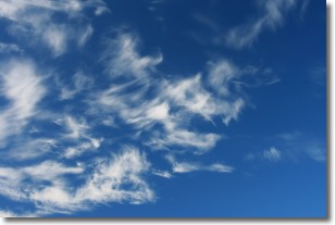
Weather Topic: What are Cirrostratus Clouds?
Home - Education - Cloud Types - Cirrostratus Clouds
 Next Topic: Cirrus Clouds
Cirrostratus clouds are high, thin clouds that form above
20,000 feet and are made mostly of ice crystals. They sometimes look like giant
feathers, horse tails, or curls of hair in the sky.
These clouds are pushed by the jet stream and can move at high speeds reaching
100 mph.
What do they indicate?
They indicate that a precipitation is likely within 24 hours.
Next Topic: Cirrus Clouds
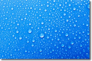
Weather Topic: What is Condensation?
Home - Education - Precipitation - Condensation
 Next Topic: Contrails
Condensation is the process which creates clouds, and therefore
it is a crucial process in the water cycle.
Condensation is the change of matter from a state of gas into a state of liquid,
and it happens because water molecules release heat into the atmosphere and
become organized into a more closely packed structure, what we might see as
water droplets.
Water is always present in the air around us as a vapor, but it's too small for
us to see. When water undergoes the process of condensation it becomes organized
into visible water droplets. You've probably seen condensation happen before on the
surface of a cold drink!
Next Topic: Contrails
Current conditions powered by WeatherAPI.com


