Weather Alert in Hawaii
Wind Advisory issued February 15 at 4:50AM HST until February 16 at 6:00AM HST by NWS Honolulu HI
AREAS AFFECTED: Kauai Southwest; Kauai Mountains; Waianae Coast; Waianae Mountains; Lanai Mauka; Kahoolawe; Maui Windward West; Maui Leeward West; Kohala; Big Island Interior; Kauai North; Kauai South; East Honolulu; Honolulu Metro; Koolau Leeward; Molokai Windward; Molokai Southeast; Molokai North; Molokai West; Molokai Leeward South; Lanai Windward; Lanai Leeward; Maui Central Valley North; Maui Central Valley South; Windward Haleakala; Kipahulu; South Haleakala; Big Island South; Big Island Southeast; Big Island North
DESCRIPTION: * WHAT...East winds 20 to 30 mph with gusts over 50 mph. * WHERE...Portions of Kahoolawe, Kauai, Lanai, Maui, Molokai, Oahu, and the Big Island Hawaii. * WHEN...Until 6 AM HST Monday. * IMPACTS...Winds this strong can tear off shingles, knock down tree branches, blow away tents and awnings and make it difficult to steer, especially for drivers of high profile vehicles.
INSTRUCTION: Watch out for falling tree branches when walking or driving. Make sure tents and awnings are secure or take them down. Be prepared for power outages. Secure trash cans, lawn furniture, and other loose outdoor objects that can be easily blown around by strong winds.
Want more detail? Get the Complete 7 Day and Night Detailed Forecast!
Current U.S. National Radar--Current
The Current National Weather Radar is shown below with a UTC Time (subtract 5 hours from UTC to get Eastern Time).

National Weather Forecast--Current
The Current National Weather Forecast and National Weather Map are shown below.

National Weather Forecast for Tomorrow
Tomorrow National Weather Forecast and Tomorrow National Weather Map are show below.

North America Water Vapor (Moisture)
This map shows recent moisture content over North America. Bright and colored areas show high moisture (ie, clouds); brown indicates very little moisture present; black indicates no moisture.

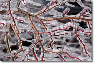
Weather Topic: What is Freezing Rain?
Home - Education - Precipitation - Freezing Rain
 Next Topic: Graupel
Freezing rain is a condition where precipitation which has fallen in the form of
water droplets reaches temperatures which are below freezing and freezes upon
coming into contact
with surface objects. The result of this precipitation is a glaze of ice which
can be damaging to plants and man-made structures. A severe onset of freezing
rain which results in a very thick glaze of ice is known as an ice storm.
Next Topic: Graupel
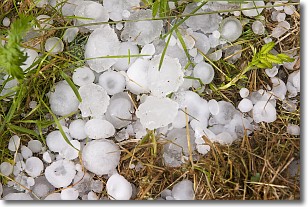
Weather Topic: What is Hail?
Home - Education - Precipitation - Hail
 Next Topic: Hole Punch Clouds
Hail is a form of precipitation which is recognized by large solid balls or
clumps of ice. Hail is created by thunderstorm clouds with strong updrafts of wind.
As the hailstones remain in the updraft, ice is deposited onto them until their
weight becomes heavy enough for them to fall to the earth's surface.
Hail storms can cause significant damage to crops, aircrafts, and man-made structures,
despite the fact that the duration is usually less than ten minutes.
Next Topic: Hole Punch Clouds
Current conditions powered by WeatherAPI.com


