Weather Alert in California
Avalanche Watch issued February 15 at 7:36AM PST by NWS Las Vegas NV
AREAS AFFECTED: Eastern Sierra Slopes of Inyo County
DESCRIPTION: AVAVEF The Eastern Sierra Avalanche Center in Mammoth Lakes has issued a Backcountry Avalanche Watch for the following areas: the Eastern Sierra in Mono County and the Eastern Sierra in Inyo County * WHAT...The avalanche danger is expected to rise to HIGH by tomorrow afternoon and remain elevated into mid-week. * WHERE...The eastern slopes of the Sierra Nevada mountain range between Virgina Lakes on the north to Bishop Creek on the south. * WHEN...In effect from Sun 07:00 PST to Mon 07:00 PST. * IMPACTS...|Heavy snow and extreme winds will create widespread areas of unstable snow.
INSTRUCTION: Very dangerous avalanche conditions are expected to develop. Avalanches may run long distances, and can run into mature forests, valley floors or flat terrain. Travel in avalanche terrain is not recommended. Consult http://www.esavalanche.org or www.avalanche.org for more detailed information Similar avalanche danger may exist at locations outside the coverage area of this or any avalanche center.
Want more detail? Get the Complete 7 Day and Night Detailed Forecast!
Current U.S. National Radar--Current
The Current National Weather Radar is shown below with a UTC Time (subtract 5 hours from UTC to get Eastern Time).

National Weather Forecast--Current
The Current National Weather Forecast and National Weather Map are shown below.

National Weather Forecast for Tomorrow
Tomorrow National Weather Forecast and Tomorrow National Weather Map are show below.

North America Water Vapor (Moisture)
This map shows recent moisture content over North America. Bright and colored areas show high moisture (ie, clouds); brown indicates very little moisture present; black indicates no moisture.

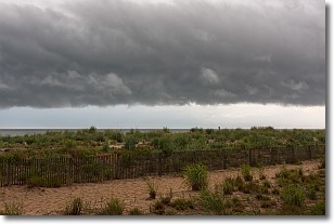
Weather Topic: What are Shelf Clouds?
Home - Education - Cloud Types - Shelf Clouds
 Next Topic: Sleet
A shelf cloud is similar to a wall cloud, but forms at the front
of a storm cloud, instead of at the rear, where wall clouds form.
A shelf cloud is caused by a series of events set into motion by the advancing
storm; first, cool air settles along the ground where precipitation has just fallen.
As the cool air is brought in, the warmer air is displaced, and rises above it,
because it is less dense. When the warmer air reaches the bottom of the storm cloud,
it begins to cool again, and the resulting condensation is a visible shelf cloud.
Next Topic: Sleet
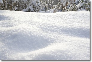
Weather Topic: What is Snow?
Home - Education - Precipitation - Snow
 Next Topic: Stratocumulus Clouds
Snow is precipitation taking the form of ice crystals. Each ice crystal, or snowflake,
has unique characteristics, but all of them grow in a hexagonal structure.
Snowfall can last for sustained periods of time and result in significant buildup
of snow on the ground.
On the earth's surface, snow starts out light and powdery, but as it begins to melt
it tends to become more granular, producing small bits of ice which have the consistency of
sand. After several cycles of melting and freezing, snow can become very dense
and ice-like, commonly known as snow pack.
Next Topic: Stratocumulus Clouds
Current conditions powered by WeatherAPI.com


