Weather Alert in Montana
Winter Storm Watch issued March 30 at 10:33PM MDT until April 3 at 6:00AM MDT by NWS Great Falls MT
AREAS AFFECTED: Southern Rocky Mountain Front; Upper Blackfoot and MacDonald Pass; Elkhorn and Boulder Mountains; Northwest Beaverhead County
DESCRIPTION: * WHAT...Heavy, wet snow possible. Total snow accumulations between 7 and 14 inches possible at and above pass level with 3 to 7 inches at lower elevations. Winds could gust as high as 40 mph. * WHERE...Elkhorn and Boulder Mountains, Upper Blackfoot and MacDonald Pass, Southern Rocky Mountain Front, and Northwest Beaverhead County. * WHEN...From Thursday morning through late Thursday night. * IMPACTS...Slushy snow covered roads and significantly reduced visibility at times may make travel very difficult. Tire chains may be required for some vehicles. Those in the backcountry should ensure they are prepared for dangerous conditions. * ADDITIONAL DETAILS...The combination of heavy, wet snow and winds may cause power outages and tree damage.
INSTRUCTION: Monitor the latest forecasts for updates on this situation. To see a graphical representation of the degree of stress on young livestock please visit our webpage and select Local Programs then Cold Air Advisory for Newborn Livestock.
Want more detail? Get the Complete 7 Day and Night Detailed Forecast!
Current U.S. National Radar--Current
The Current National Weather Radar is shown below with a UTC Time (subtract 5 hours from UTC to get Eastern Time).

National Weather Forecast--Current
The Current National Weather Forecast and National Weather Map are shown below.

National Weather Forecast for Tomorrow
Tomorrow National Weather Forecast and Tomorrow National Weather Map are show below.

North America Water Vapor (Moisture)
This map shows recent moisture content over North America. Bright and colored areas show high moisture (ie, clouds); brown indicates very little moisture present; black indicates no moisture.

Weather Topic: What are Stratus Clouds?
Home - Education - Cloud Types - Stratus Clouds
 Next Topic: Wall Clouds
Stratus clouds are similar to altostratus clouds, but form at a
lower altitude and are identified by their fog-like appearance, lacking the
distinguishing features of most clouds.
Stratus clouds are wider than most clouds, and their base has a smooth, uniform
look which is lighter in color than a nimbostratus cloud.
The presence of a stratus cloud indicates the possibility of minor precipitation,
such as drizzle, but heavier precipitation does not typically arrive in the form
of a stratus cloud.
Next Topic: Wall Clouds
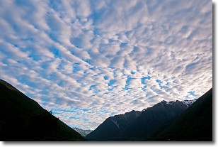
Weather Topic: What are Altocumulus Clouds?
Home - Education - Cloud Types - Altocumulus Clouds
 Next Topic: Altostratus Clouds
Similar to cirrocumulus clouds, altocumulus clouds are
characterized by cloud patches. They are distinguished by larger cloudlets
than cirrocumulus clouds but are still smaller than stratocumulus clouds.
Altocumulus clouds most commonly form in middle altitudes (between 2 and 5 km)
and may resemble, at times, the shape of a flying saucer.
These uncommon formations, called altocumulus lenticularis, are created by uplift
in the atmosphere and are most often seen in close proximity to mountains.
Next Topic: Altostratus Clouds
Current conditions powered by WeatherAPI.com


