Weather Alert in Montana
Winter Storm Watch issued March 30 at 10:33PM MDT until April 3 at 6:00AM MDT by NWS Great Falls MT
AREAS AFFECTED: Southern Rocky Mountain Front; Upper Blackfoot and MacDonald Pass; Elkhorn and Boulder Mountains; Northwest Beaverhead County
DESCRIPTION: * WHAT...Heavy, wet snow possible. Total snow accumulations between 7 and 14 inches possible at and above pass level with 3 to 7 inches at lower elevations. Winds could gust as high as 40 mph. * WHERE...Elkhorn and Boulder Mountains, Upper Blackfoot and MacDonald Pass, Southern Rocky Mountain Front, and Northwest Beaverhead County. * WHEN...From Thursday morning through late Thursday night. * IMPACTS...Slushy snow covered roads and significantly reduced visibility at times may make travel very difficult. Tire chains may be required for some vehicles. Those in the backcountry should ensure they are prepared for dangerous conditions. * ADDITIONAL DETAILS...The combination of heavy, wet snow and winds may cause power outages and tree damage.
INSTRUCTION: Monitor the latest forecasts for updates on this situation. To see a graphical representation of the degree of stress on young livestock please visit our webpage and select Local Programs then Cold Air Advisory for Newborn Livestock.
Want more detail? Get the Complete 7 Day and Night Detailed Forecast!
Current U.S. National Radar--Current
The Current National Weather Radar is shown below with a UTC Time (subtract 5 hours from UTC to get Eastern Time).

National Weather Forecast--Current
The Current National Weather Forecast and National Weather Map are shown below.

National Weather Forecast for Tomorrow
Tomorrow National Weather Forecast and Tomorrow National Weather Map are show below.

North America Water Vapor (Moisture)
This map shows recent moisture content over North America. Bright and colored areas show high moisture (ie, clouds); brown indicates very little moisture present; black indicates no moisture.

Weather Topic: What is Graupel?
Home - Education - Precipitation - Graupel
 Next Topic: Hail
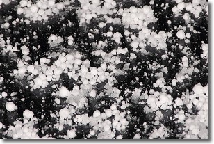
Graupel is a form of precipitation that is created by atmospheric conditions
which cause supercooled water droplets to contact snow crystals and freeze to
their surface.
Sometimes known as soft hail or snow pellets, graupel is delicate and easily
destroyed by touch. Whereas hail usually falls during severe weather, graupel
doesn't require such conditions to form, and can form in mild precipitation
similar to situations which produce snowfall.
Next Topic: Hail
Weather Topic: What are Hole Punch Clouds?
Home - Education - Cloud Types - Hole Punch Clouds
 Next Topic: Mammatus Clouds
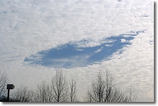
A hole punch cloud is an unusual occurrence when a disk-shaped
hole appears in a cirrostratus, cirrocumulus, or altocumulus cloud.
When part of the cloud forms ice crystals, water droplets in the surrounding area
of the cloud evaporate. The effect of this process produces a large elliptical
gap in the cloud. The hole punch cloud formation is rare, but it is not specific
to any geographic area.
Other names which have been used to describe this phenomena include fallstreak hole,
skypunch, and cloud hole.
Next Topic: Mammatus Clouds
Current conditions powered by WeatherAPI.com


