Weather Alert in Montana
Winter Storm Watch issued March 30 at 10:33PM MDT until April 3 at 12:00PM MDT by NWS Great Falls MT
AREAS AFFECTED: Cascade County below 5000ft; Judith Basin County and Judith Gap; Fergus County below 4500ft; Little Belt and Highwood Mountains; Snowy and Judith Mountains; Big Belt, Bridger and Castle Mountains; Gallatin and Madison County Mountains and Centennial Mountains
DESCRIPTION: * WHAT...Heavy, wet snow possible. Total snow accumulations between 4 and 8 inches possible at elevations below 5,000 feet and 8 to 16 inches possible above 5,000 feet. Winds could gust as high as 40 mph. * WHERE...Portions of central, north central, and southwest Montana. * WHEN...From Thursday afternoon through Friday morning. * IMPACTS...Slushy snow covered roads and significantly reduced visibility at times may make travel very difficult. The hazardous conditions could impact the Thursday evening and Friday morning commutes. Those in the backcountry should ensure they are prepared for dangerous conditions. * ADDITIONAL DETAILS...The combination of heavy, wet snow and winds may cause power outages and tree damage.
INSTRUCTION: Monitor the latest forecasts for updates on this situation. To see a graphical representation of the degree of stress on young livestock please visit our webpage and select Local Programs then Cold Air Advisory for Newborn Livestock.
Want more detail? Get the Complete 7 Day and Night Detailed Forecast!
Current U.S. National Radar--Current
The Current National Weather Radar is shown below with a UTC Time (subtract 5 hours from UTC to get Eastern Time).

National Weather Forecast--Current
The Current National Weather Forecast and National Weather Map are shown below.

National Weather Forecast for Tomorrow
Tomorrow National Weather Forecast and Tomorrow National Weather Map are show below.

North America Water Vapor (Moisture)
This map shows recent moisture content over North America. Bright and colored areas show high moisture (ie, clouds); brown indicates very little moisture present; black indicates no moisture.

Weather Topic: What is Freezing Rain?
Home - Education - Precipitation - Freezing Rain
 Next Topic: Graupel
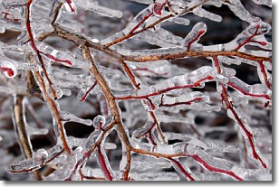
Freezing rain is a condition where precipitation which has fallen in the form of
water droplets reaches temperatures which are below freezing and freezes upon
coming into contact
with surface objects. The result of this precipitation is a glaze of ice which
can be damaging to plants and man-made structures. A severe onset of freezing
rain which results in a very thick glaze of ice is known as an ice storm.
Next Topic: Graupel
Weather Topic: What is Hail?
Home - Education - Precipitation - Hail
 Next Topic: Hole Punch Clouds
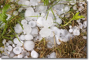
Hail is a form of precipitation which is recognized by large solid balls or
clumps of ice. Hail is created by thunderstorm clouds with strong updrafts of wind.
As the hailstones remain in the updraft, ice is deposited onto them until their
weight becomes heavy enough for them to fall to the earth's surface.
Hail storms can cause significant damage to crops, aircrafts, and man-made structures,
despite the fact that the duration is usually less than ten minutes.
Next Topic: Hole Punch Clouds
Current conditions powered by WeatherAPI.com


