Weather Alert in Nebraska
Fire Weather Watch issued February 16 at 12:35AM MST until February 17 at 6:00PM MST by NWS Cheyenne WY
AREAS AFFECTED: Pine Ridge/Nebraska National Forest; Box Butte/South Sioux/Niobrara River; Lower North Platte River Basin/Scottsbluff National Monument; Lodgepole Creek/Southern Nebraska Panhandle; Niobrara/Lower Elevations of Converse/Thunder Basin National Grassland; Middle North Platte River Basin/Niobrara and Converse High Plains; Laramie Foothills and High Plains; Laramie East High Plains; Bordeaux/Chugwater/Wheatland; Goshen/Middle-Lower North Platte River Basin
DESCRIPTION: The National Weather Service in Cheyenne has issued a Fire Weather Watch, which is in effect from late tonight through Tuesday afternoon. * AFFECTED AREA...Fire weather zone 434, 435, 436, 437, 417, 418, 430, 431, 432, and 433. * WIND...In the morning, southwest winds 10 to 20 MPH with gusts up to 30 MPH becoming west 25 to 40 MPH with gusts up to 65 MPH possible in the late morning and afternoon. * HUMIDITY...13 to 20 percent. Very low humidity recoveries possible early in the morning. * HIGHEST THREAT...Just east of the Laramie Range across southeast Wyoming and the Interstate 25 corridor. Very low humidity recoveries for this time of the year are expected as winds quickly increase above criteria, as early as 600 AM. * IMPACTS...any fires that develop will likely spread rapidly. Outdoor burning is not recommended.
INSTRUCTION: A Fire Weather Watch means that critical fire weather conditions are forecast to occur. Listen for later forecasts and possible Red Flag Warnings.
Want more detail? Get the Complete 7 Day and Night Detailed Forecast!
Current U.S. National Radar--Current
The Current National Weather Radar is shown below with a UTC Time (subtract 5 hours from UTC to get Eastern Time).

National Weather Forecast--Current
The Current National Weather Forecast and National Weather Map are shown below.

National Weather Forecast for Tomorrow
Tomorrow National Weather Forecast and Tomorrow National Weather Map are show below.

North America Water Vapor (Moisture)
This map shows recent moisture content over North America. Bright and colored areas show high moisture (ie, clouds); brown indicates very little moisture present; black indicates no moisture.

Weather Topic: What are Shelf Clouds?
Home - Education - Cloud Types - Shelf Clouds
 Next Topic: Sleet
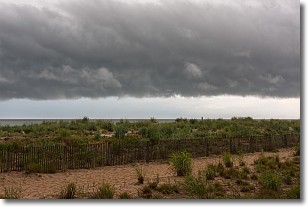
A shelf cloud is similar to a wall cloud, but forms at the front
of a storm cloud, instead of at the rear, where wall clouds form.
A shelf cloud is caused by a series of events set into motion by the advancing
storm; first, cool air settles along the ground where precipitation has just fallen.
As the cool air is brought in, the warmer air is displaced, and rises above it,
because it is less dense. When the warmer air reaches the bottom of the storm cloud,
it begins to cool again, and the resulting condensation is a visible shelf cloud.
Next Topic: Sleet
Weather Topic: What is Snow?
Home - Education - Precipitation - Snow
 Next Topic: Stratocumulus Clouds
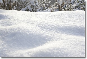
Snow is precipitation taking the form of ice crystals. Each ice crystal, or snowflake,
has unique characteristics, but all of them grow in a hexagonal structure.
Snowfall can last for sustained periods of time and result in significant buildup
of snow on the ground.
On the earth's surface, snow starts out light and powdery, but as it begins to melt
it tends to become more granular, producing small bits of ice which have the consistency of
sand. After several cycles of melting and freezing, snow can become very dense
and ice-like, commonly known as snow pack.
Next Topic: Stratocumulus Clouds
Current conditions powered by WeatherAPI.com


