Weather Alert in California
Flood Warning issued February 24 at 7:47PM PST until February 26 at 9:52AM PST by NWS Sacramento CA
AREAS AFFECTED: Tehama, CA
DESCRIPTION: ...The National Weather Service in Sacramento CA has issued a Flood Warning for the following rivers in California... Sacramento River At Tehama Bridge affecting Tehama County. Sacramento River At Vina Woodson Bridge affecting Tehama County. .Minor Flooding At Tehama Bridge and Vina Woodson; Action/Monitor Stage for Most Forecast Points Along the Upper Sacramento River System. For the Upper Sacramento River...including Tehama Bridge and Vina Woodson Bridge...Minor flooding is forecast. * WHAT...Minor flooding is forecast. * WHERE...Sacramento River at Tehama Bridge. * WHEN...From this evening to late Thursday morning. * IMPACTS...At 210.7 feet, Between 210 and 211 feet the county park becomes inaccessible. At 211 feet water begins to enter Driftwood RV fishing resort on east bank of river and just north of the county park. * ADDITIONAL DETAILS... - At 7:00 PM PST Tuesday the stage was 206.1 feet. - Bankfull stage is 206.5 feet. - Forecast...The river is expected to rise above flood stage late this evening to a crest of 212.4 feet tomorrow morning. It will then fall below flood stage tomorrow afternoon. - Flood stage is 209.5 feet. - Flood History...This crest compares to a previous crest of 212.3 feet on 02/19/2024. - http://www.weather.gov/safety/flood
INSTRUCTION: Turn around, don't drown when encountering flooded roads. Most flood deaths occur in vehicles. For more hydrologic information and stage definitions refer to the following web site: wrh.noaa.gov/sto/hydro_data.php The next statement will be issued Wednesday evening at 800 PM PST.
Want more detail? Get the Complete 7 Day and Night Detailed Forecast!
Current U.S. National Radar--Current
The Current National Weather Radar is shown below with a UTC Time (subtract 5 hours from UTC to get Eastern Time).

National Weather Forecast--Current
The Current National Weather Forecast and National Weather Map are shown below.

National Weather Forecast for Tomorrow
Tomorrow National Weather Forecast and Tomorrow National Weather Map are show below.

North America Water Vapor (Moisture)
This map shows recent moisture content over North America. Bright and colored areas show high moisture (ie, clouds); brown indicates very little moisture present; black indicates no moisture.

Weather Topic: What are Stratus Clouds?
Home - Education - Cloud Types - Stratus Clouds
 Next Topic: Wall Clouds
Stratus clouds are similar to altostratus clouds, but form at a
lower altitude and are identified by their fog-like appearance, lacking the
distinguishing features of most clouds.
Stratus clouds are wider than most clouds, and their base has a smooth, uniform
look which is lighter in color than a nimbostratus cloud.
The presence of a stratus cloud indicates the possibility of minor precipitation,
such as drizzle, but heavier precipitation does not typically arrive in the form
of a stratus cloud.
Next Topic: Wall Clouds
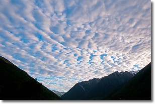
Weather Topic: What are Altocumulus Clouds?
Home - Education - Cloud Types - Altocumulus Clouds
 Next Topic: Altostratus Clouds
Similar to cirrocumulus clouds, altocumulus clouds are
characterized by cloud patches. They are distinguished by larger cloudlets
than cirrocumulus clouds but are still smaller than stratocumulus clouds.
Altocumulus clouds most commonly form in middle altitudes (between 2 and 5 km)
and may resemble, at times, the shape of a flying saucer.
These uncommon formations, called altocumulus lenticularis, are created by uplift
in the atmosphere and are most often seen in close proximity to mountains.
Next Topic: Altostratus Clouds
Current conditions powered by WeatherAPI.com


