Weather Alert in Washington
Winter Weather Advisory issued March 9 at 1:58PM PDT until March 10 at 8:00AM PDT by NWS Pendleton OR
AREAS AFFECTED: Upper Slopes of the Eastern Washington Cascades Crest
DESCRIPTION: * WHAT...Winter Weather Advisory, snow. Additional snow accumulations between 2 and 6 inches. Winds gusting as high as 30 mph rest of today. Winter Storm Warning, heavy snow expected. Total snow accumulations between 1 and 3 feet. Winds gusting as high as 35 mph 11 pm Wednesday to 5 pm Thursday. * WHERE...Upper Slopes of the Eastern Washington Cascades Crest. * WHEN...For the Winter Weather Advisory, until 8 AM PDT Tuesday. For the Winter Storm Warning, from 5 PM Tuesday to 5 AM PDT Friday. * IMPACTS...Heavy snowfall and very low visibility will create extremely dangerous driving conditions. Gusty winds could bring down tree branches. * ADDITIONAL DETAILS...A strong winter storm will bring heavy mountain snow Tuesday night through Friday morning. There is a lull expected which will occur late Wednesday morning through early Thursday morning as snow levels rise bringing a wintery mix or rain before decreasing Thursday returning heavy snow to pass-level.
INSTRUCTION: Persons should consider delaying all travel. If travel is absolutely necessary, drive with extreme caution. Consider taking a winter storm kit along with you, including such items as tire chains, booster cables, flashlight, shovel, blankets and extra clothing. Also take water, a first aid kit, and anything else that would help you survive in case you become stranded. Do not touch downed lines and report any power outages to your electric company. Travel is highly discouraged due to slick roadways and the possibility of downed trees and power lines. Slow down and use caution while traveling. The latest road conditions can be obtained by visiting the website wsdot.wa.gov/travel.
Want more detail? Get the Complete 7 Day and Night Detailed Forecast!
Current U.S. National Radar--Current
The Current National Weather Radar is shown below with a UTC Time (subtract 5 hours from UTC to get Eastern Time).

National Weather Forecast--Current
The Current National Weather Forecast and National Weather Map are shown below.

National Weather Forecast for Tomorrow
Tomorrow National Weather Forecast and Tomorrow National Weather Map are show below.

North America Water Vapor (Moisture)
This map shows recent moisture content over North America. Bright and colored areas show high moisture (ie, clouds); brown indicates very little moisture present; black indicates no moisture.

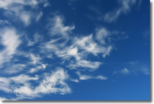
Weather Topic: What are Cirrostratus Clouds?
Home - Education - Cloud Types - Cirrostratus Clouds
 Next Topic: Cirrus Clouds
Cirrostratus clouds are high, thin clouds that form above
20,000 feet and are made mostly of ice crystals. They sometimes look like giant
feathers, horse tails, or curls of hair in the sky.
These clouds are pushed by the jet stream and can move at high speeds reaching
100 mph.
What do they indicate?
They indicate that a precipitation is likely within 24 hours.
Next Topic: Cirrus Clouds
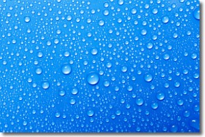
Weather Topic: What is Condensation?
Home - Education - Precipitation - Condensation
 Next Topic: Contrails
Condensation is the process which creates clouds, and therefore
it is a crucial process in the water cycle.
Condensation is the change of matter from a state of gas into a state of liquid,
and it happens because water molecules release heat into the atmosphere and
become organized into a more closely packed structure, what we might see as
water droplets.
Water is always present in the air around us as a vapor, but it's too small for
us to see. When water undergoes the process of condensation it becomes organized
into visible water droplets. You've probably seen condensation happen before on the
surface of a cold drink!
Next Topic: Contrails
Current conditions powered by WeatherAPI.com


