Weather Alert in Hawaii
Coastal Flood Statement issued September 3 at 3:03AM HST until September 7 at 6:00PM HST by NWS Honolulu HI
AREAS AFFECTED: Niihau; Kauai Southwest; Waianae Coast; Oahu North Shore; Olomana; Kahoolawe; Maui Windward West; Maui Leeward West; Kona; Kohala; Kauai North; Kauai East; Kauai South; East Honolulu; Honolulu Metro; Ewa Plain; Koolau Windward; Molokai Windward; Molokai Southeast; Molokai North; Molokai West; Molokai Leeward South; Lanai Windward; Lanai Leeward; Lanai South; Maui Central Valley North; Maui Central Valley South; Windward Haleakala; Kipahulu; South Maui/Upcountry; South Haleakala; Big Island South; Big Island Southeast; Big Island East; Big Island North
DESCRIPTION: ...MINOR COASTAL FLOODING DURING THE HIGH TIDE THROUGH SUNDAY AFTERNOON FOR LOW LYING COASTAL AREAS OF ALL ISLANDS... Peak high tides associated with the lunar cycle will lead to minor coastal flooding along shorelines and low lying coastal areas during the daily afternoon high tide through Sunday. * WHAT...Isolated minor coastal flooding expected. * WHERE...Vulnerable low-lying coastal roadways, docks, boat ramps, and other coastal infrastructure. * WHEN...Through the afternoon hours Wednesday through Sunday at and around the daily peak tides. * IMPACTS...Flooding of beaches that are normally dry, minor coastal erosion, and saltwater inundation.
INSTRUCTION: Avoid driving through flooded roadways. If you are forced to drive through salt water, be sure to rinse your vehicle with fresh water. Move electronics, vehicles or other valuables to higher ground. Monitor vessels to ensure mooring lines don't get too tight and watch out for overwash around boat ramps. Secure canoes or other watercraft stowed on beaches.
Want more detail? Get the Complete 7 Day and Night Detailed Forecast!
Current U.S. National Radar--Current
The Current National Weather Radar is shown below with a UTC Time (subtract 5 hours from UTC to get Eastern Time).

National Weather Forecast--Current
The Current National Weather Forecast and National Weather Map are shown below.

National Weather Forecast for Tomorrow
Tomorrow National Weather Forecast and Tomorrow National Weather Map are show below.

North America Water Vapor (Moisture)
This map shows recent moisture content over North America. Bright and colored areas show high moisture (ie, clouds); brown indicates very little moisture present; black indicates no moisture.

Weather Topic: What are Cumulonimbus Clouds?
Home - Education - Cloud Types - Cumulonimbus Clouds
 Next Topic: Cumulus Clouds
The final form taken by a growing cumulus cloud is the
cumulonimbus cloud, which is very tall and dense.
The tower of a cumulonimbus cloud can soar 23 km into the atmosphere, although
most commonly they stop growing at an altitude of 6 km.
Even small cumulonimbus clouds appear very large in comparison to other cloud types.
They can signal the approach of stormy weather, such as thunderstorms or blizzards.
Next Topic: Cumulus Clouds
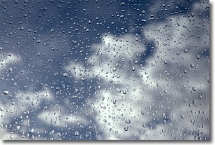
Weather Topic: What is Drizzle?
Home - Education - Precipitation - Drizzle
 Next Topic: Evaporation
Drizzle is precipitation in the form of water droplets which are
smaller than raindrops.
Drizzle is characterized by fine, gently falling droplets and typically does not
impact human habitation in a negative way. The exception to this is freezing drizzle,
a condition where drizzle freezes immediately upon reaching earth's surface.
Freezing drizzle is still less dangerous than freezing rain, but can
potentially result in hazardous road conditions.
Next Topic: Evaporation
Current conditions powered by WeatherAPI.com


