Weather Alert in Louisiana
Severe Thunderstorm Warning issued February 14 at 11:12PM CST until February 15 at 12:00AM CST by NWS New Orleans LA
AREAS AFFECTED: Ascension, LA; Assumption, LA; East Baton Rouge, LA; Iberville, LA; Livingston, LA; West Baton Rouge, LA
DESCRIPTION: SVRLIX The National Weather Service in New Orleans has issued a * Severe Thunderstorm Warning for... Ascension Parish in southeastern Louisiana... West Baton Rouge Parish in southeastern Louisiana... Southwestern Livingston Parish in southeastern Louisiana... Iberville Parish in southeastern Louisiana... Southwestern East Baton Rouge Parish in southeastern Louisiana... Northwestern Assumption Parish in southeastern Louisiana... * Until midnight CST. * At 1111 PM CST, severe thunderstorms were located along a line extending from 6 miles west of Baker to near Ramah to near Lydia, moving east at 40 mph. HAZARD...60 mph wind gusts and penny size hail. SOURCE...Radar indicated. IMPACT...Expect damage to roofs, siding, and trees. * Locations impacted include... Baton Rouge, Denham Springs, Gonzales, Donaldsonville, Plaquemine, Port Allen, Oak Hills Place, St. Gabriel, Walker, Addis, Brusly, White Castle, Livingston, Sorrento, French Settlement, Rosedale, Port Vincent, Grosse Tete, Westminster, and Geismar. This includes the following Interstates... Interstate 10 in Louisiana between mile markers 136 and 182. Interstate 12 between mile markers 1 and 28. Interstate 110 in Louisiana between mile markers 1 and 5.
INSTRUCTION: Remain alert for a possible tornado! Tornadoes can develop quickly from severe thunderstorms. If you spot a tornado go at once into the basement or small central room in a sturdy structure. For your protection move to an interior room on the lowest floor of a building. A Tornado Watch remains in effect until 200 AM CST for southeastern Louisiana.
Want more detail? Get the Complete 7 Day and Night Detailed Forecast!
Current U.S. National Radar--Current
The Current National Weather Radar is shown below with a UTC Time (subtract 5 hours from UTC to get Eastern Time).

National Weather Forecast--Current
The Current National Weather Forecast and National Weather Map are shown below.

National Weather Forecast for Tomorrow
Tomorrow National Weather Forecast and Tomorrow National Weather Map are show below.

North America Water Vapor (Moisture)
This map shows recent moisture content over North America. Bright and colored areas show high moisture (ie, clouds); brown indicates very little moisture present; black indicates no moisture.

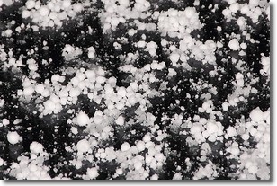
Weather Topic: What is Graupel?
Home - Education - Precipitation - Graupel
 Next Topic: Hail
Graupel is a form of precipitation that is created by atmospheric conditions
which cause supercooled water droplets to contact snow crystals and freeze to
their surface.
Sometimes known as soft hail or snow pellets, graupel is delicate and easily
destroyed by touch. Whereas hail usually falls during severe weather, graupel
doesn't require such conditions to form, and can form in mild precipitation
similar to situations which produce snowfall.
Next Topic: Hail
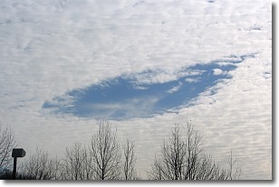
Weather Topic: What are Hole Punch Clouds?
Home - Education - Cloud Types - Hole Punch Clouds
 Next Topic: Mammatus Clouds
A hole punch cloud is an unusual occurrence when a disk-shaped
hole appears in a cirrostratus, cirrocumulus, or altocumulus cloud.
When part of the cloud forms ice crystals, water droplets in the surrounding area
of the cloud evaporate. The effect of this process produces a large elliptical
gap in the cloud. The hole punch cloud formation is rare, but it is not specific
to any geographic area.
Other names which have been used to describe this phenomena include fallstreak hole,
skypunch, and cloud hole.
Next Topic: Mammatus Clouds
Current conditions powered by WeatherAPI.com


