Weather Alert in Arizona
Flash Flood Warning issued September 4 at 12:09PM MST until September 4 at 6:15PM MST by NWS Flagstaff AZ
AREAS AFFECTED: Coconino, AZ
DESCRIPTION: FFWFGZ The National Weather Service in Flagstaff has issued a * Flash Flood Warning for... The North Canyon Wash Basin downstream of the Dragon Bravo Fire scar in...Coconino County in north central Arizona...this includes the Colorado River between mile markers 17 and 21. * Until 615 PM MST /715 PM MDT/ Thursday. * At 1209 PM MST /109 PM MDT/, Doppler radar indicated thunderstorms producing heavy rain over the North Canyon Wash Basin downstream of the Dragon Bravo Fire scar. Flash flooding is ongoing or expected to begin shortly. Excessive rainfall over the burn scar will result in debris flow moving through the North Canyon Wash. The debris flow can consist of rock, mud, vegetation and other loose materials. HAZARD...Life threatening flash flooding. Thunderstorms producing flash flooding in and around the North Canyon Wash Basin downstream of the Dragon Bravo Fire scar. SOURCE...Radar indicated. IMPACT...Life threatening flash flooding of areas in and around the North Canyon Wash Basin downstream of the Dragon Bravo Fire scar. * Some locations that will experience flash flooding include... Grand Canyon National Park and Saddle Mountain Wilderness. This includes the Colorado River between mile markers 17 and 21. This includes the following recreation areas and campgrounds... House Rock Camp Site, 18 Mile Wash Camp Site, 18 Mile Ledges Camp Site, Upper North Canyon Camp Site and Lower North Canyon Camp Site. This includes the following creeks, washes and rivers... North Canyon, "18- Mile Wash", "19- Mile Canyon", Colorado River, South Canyon, House Rock Wash, Hanaa Ninadzidzahi and North Canyon Wash.
INSTRUCTION: Flash flooding is occurring or imminent downstream of the Dragon Bravo Fire scar. Severe debris flow are expected across roads and in remote canyon drainages on the Kaibab Plateau east of State Route 67. Campers and hikers should get away from creeks and move to higher ground immediately! Stay away or be swept away!
Want more detail? Get the Complete 7 Day and Night Detailed Forecast!
Current U.S. National Radar--Current
The Current National Weather Radar is shown below with a UTC Time (subtract 5 hours from UTC to get Eastern Time).

National Weather Forecast--Current
The Current National Weather Forecast and National Weather Map are shown below.

National Weather Forecast for Tomorrow
Tomorrow National Weather Forecast and Tomorrow National Weather Map are show below.

North America Water Vapor (Moisture)
This map shows recent moisture content over North America. Bright and colored areas show high moisture (ie, clouds); brown indicates very little moisture present; black indicates no moisture.

Weather Topic: What is Freezing Rain?
Home - Education - Precipitation - Freezing Rain
 Next Topic: Graupel
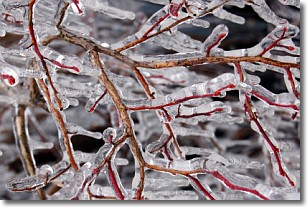
Freezing rain is a condition where precipitation which has fallen in the form of
water droplets reaches temperatures which are below freezing and freezes upon
coming into contact
with surface objects. The result of this precipitation is a glaze of ice which
can be damaging to plants and man-made structures. A severe onset of freezing
rain which results in a very thick glaze of ice is known as an ice storm.
Next Topic: Graupel
Weather Topic: What is Hail?
Home - Education - Precipitation - Hail
 Next Topic: Hole Punch Clouds
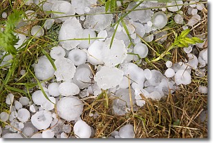
Hail is a form of precipitation which is recognized by large solid balls or
clumps of ice. Hail is created by thunderstorm clouds with strong updrafts of wind.
As the hailstones remain in the updraft, ice is deposited onto them until their
weight becomes heavy enough for them to fall to the earth's surface.
Hail storms can cause significant damage to crops, aircrafts, and man-made structures,
despite the fact that the duration is usually less than ten minutes.
Next Topic: Hole Punch Clouds
Current conditions powered by WeatherAPI.com


