Weather Alert in California
Frost Advisory issued March 9 at 9:50PM PDT until March 10 at 9:00AM PDT by NWS Eureka CA
AREAS AFFECTED: Coastal Del Norte; Northern Humboldt Coast; Mendocino Coast; Northwestern Mendocino Interior; Northeastern Mendocino Interior; Southwestern Mendocino Interior; Southeastern Mendocino Interior; Northern Lake County; Southern Lake County
DESCRIPTION: * WHAT...Temperatures as low as 33 will result in frost formation. * WHERE...Mendocino County, Lake County, and Del Norte and Northern Humboldt Coast. * WHEN...From 3 AM to 9 AM PDT Tuesday. * IMPACTS...Frost could harm sensitive outdoor vegetation. Sensitive outdoor plants may be killed if left uncovered. * ADDITIONAL DETAILS...*Frost formation is most likely to occur for NE Mendocino County, including: Legget, Laytonville, Covelo, Willits, and Potter Valley. Other areas in Mendocino county include: Philo and Calpella. *Frost may occur in areas of Lake (Upper Lake), Humboldt (McKinleyville, Blue Lake, and Fieldbrook), and Del Norte (Hiouchi)
INSTRUCTION: Take steps now to protect tender plants from the cold.
Want more detail? Get the Complete 7 Day and Night Detailed Forecast!
Current U.S. National Radar--Current
The Current National Weather Radar is shown below with a UTC Time (subtract 5 hours from UTC to get Eastern Time).

National Weather Forecast--Current
The Current National Weather Forecast and National Weather Map are shown below.

National Weather Forecast for Tomorrow
Tomorrow National Weather Forecast and Tomorrow National Weather Map are show below.

North America Water Vapor (Moisture)
This map shows recent moisture content over North America. Bright and colored areas show high moisture (ie, clouds); brown indicates very little moisture present; black indicates no moisture.

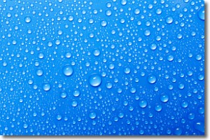
Weather Topic: What is Condensation?
Home - Education - Precipitation - Condensation
 Next Topic: Contrails
Condensation is the process which creates clouds, and therefore
it is a crucial process in the water cycle.
Condensation is the change of matter from a state of gas into a state of liquid,
and it happens because water molecules release heat into the atmosphere and
become organized into a more closely packed structure, what we might see as
water droplets.
Water is always present in the air around us as a vapor, but it's too small for
us to see. When water undergoes the process of condensation it becomes organized
into visible water droplets. You've probably seen condensation happen before on the
surface of a cold drink!
Next Topic: Contrails
Weather Topic: What are Cumulonimbus Clouds?
Home - Education - Cloud Types - Cumulonimbus Clouds
 Next Topic: Cumulus Clouds
The final form taken by a growing cumulus cloud is the
cumulonimbus cloud, which is very tall and dense.
The tower of a cumulonimbus cloud can soar 23 km into the atmosphere, although
most commonly they stop growing at an altitude of 6 km.
Even small cumulonimbus clouds appear very large in comparison to other cloud types.
They can signal the approach of stormy weather, such as thunderstorms or blizzards.
Next Topic: Cumulus Clouds
Current conditions powered by WeatherAPI.com


