Weather Alert in Alaska
Cold Weather Advisory issued March 7 at 1:42AM AKST until March 9 at 1:00PM AKDT by NWS Anchorage AK
AREAS AFFECTED: Kuskokwim Delta Coast and Nunivak Island; Interior Kuskokwim Delta; Western Capes
DESCRIPTION: * WHAT...Very cold wind chills from 20 below to 40 below. * WHERE...Kuskokwim Delta, and Western Capes. * WHEN...Until 1 PM AKDT Monday. * IMPACTS...The dangerously cold wind chills as low as 40 below zero could cause frostbite on exposed skin in as little as 10 minutes. Frostbite and hypothermia are likely if exposed to these temperatures. Wind chill values can lead to hypothermia with prolonged exposure. * ADDITIONAL DETAILS...Cold northerly flow and enhanced wind gusts will lead to a period of frigid wind chills over the weekend through Monday morning. Winds expected to be relatively stronger along the coast, but temperatures will be lower inland near Bethel. Expect coldest temperatures overnight, increasing during daytime hours, and returning to frigid conditions overnight. By Monday afternoon, a slight warming trend and decrease in wind speeds will occur, raising wind chills closer to 10 below.
INSTRUCTION: Use caution while traveling outside. Wear appropriate clothing, a hat, and gloves. Keep pets indoors as much as possible. Make frequent checks on older family, friends, and neighbors. Ensure portable heaters are used correctly. Do not use generators or grills inside.
Want more detail? Get the Complete 7 Day and Night Detailed Forecast!
Current U.S. National Radar--Current
The Current National Weather Radar is shown below with a UTC Time (subtract 5 hours from UTC to get Eastern Time).

National Weather Forecast--Current
The Current National Weather Forecast and National Weather Map are shown below.

National Weather Forecast for Tomorrow
Tomorrow National Weather Forecast and Tomorrow National Weather Map are show below.

North America Water Vapor (Moisture)
This map shows recent moisture content over North America. Bright and colored areas show high moisture (ie, clouds); brown indicates very little moisture present; black indicates no moisture.

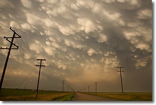
Weather Topic: What are Mammatus Clouds?
Home - Education - Cloud Types - Mammatus Clouds
 Next Topic: Nimbostratus Clouds
A mammatus cloud is a cloud with a unique feature which resembles
a web of pouches hanging along the base of the cloud.
In the United States, mammatus clouds tend to form in the warmer months, commonly
in the Midwest and eastern regions.
While they usually form at the bottom of a cumulonimbis cloud, they can also form
under altostratus, altocumulus, stratocumulus, and cirrus clouds. Mammatus clouds
warn that severe weather is close.
Next Topic: Nimbostratus Clouds
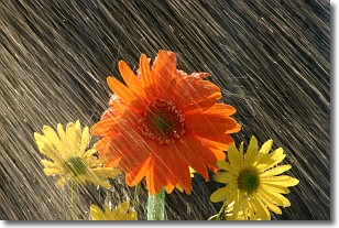
Weather Topic: What is Precipitation?
Home - Education - Precipitation - Precipitation
 Next Topic: Rain
Precipitation can refer to many different forms of water that
may fall from clouds. Precipitation occurs after a cloud has become saturated to
the point where its water particles are more dense than the air below the cloud.
In most cases, precipitation will reach the ground, but it is not uncommon for
precipitation to evaporate before it reaches the earth's surface.
When precipitation evaporates before it contacts the ground it is called Virga.
Graupel, hail, sleet, rain, drizzle, and snow are forms of precipitation, but fog
and mist are not considered precipitation because the water vapor which
constitutes them isn't dense enough to fall to the ground.
Next Topic: Rain
Current conditions powered by WeatherAPI.com


