Weather Alert in Vermont
Special Weather Statement issued September 4 at 4:31AM EDT by NWS Albany NY
AREAS AFFECTED: Bennington; Western Windham; Eastern Windham
DESCRIPTION: Fine fuels remain very dry across the area according to the Vermont Department of Forests, Parks and Recreation. Southerly winds today will increase to 10 to 15 mph with gusts up to 25 mph across southern Vermont. This, combined with expected low relative humidity values between 35 and 40 percent will create near critical fire weather conditions this afternoon. Winds will be strongest between noon and 8 PM, coinciding with the timing of the minimum relative humidity values. If any fires were to start, the weather and fuel conditions could cause fires to quickly get out of control and be difficult to contain. Fire weather conditions will quickly improve with a wetting rainfall expected this evening into tonight. For more information about the current fire danger rating, any burn restrictions, and wildfire prevention and education, please visit your state forestry or environmental protection website.
INSTRUCTION: N/A
Want more detail? Get the Complete 7 Day and Night Detailed Forecast!
Current U.S. National Radar--Current
The Current National Weather Radar is shown below with a UTC Time (subtract 5 hours from UTC to get Eastern Time).

National Weather Forecast--Current
The Current National Weather Forecast and National Weather Map are shown below.

National Weather Forecast for Tomorrow
Tomorrow National Weather Forecast and Tomorrow National Weather Map are show below.

North America Water Vapor (Moisture)
This map shows recent moisture content over North America. Bright and colored areas show high moisture (ie, clouds); brown indicates very little moisture present; black indicates no moisture.

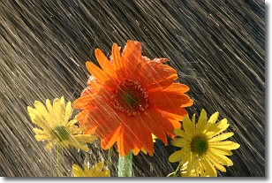
Weather Topic: What is Precipitation?
Home - Education - Precipitation - Precipitation
 Next Topic: Rain
Precipitation can refer to many different forms of water that
may fall from clouds. Precipitation occurs after a cloud has become saturated to
the point where its water particles are more dense than the air below the cloud.
In most cases, precipitation will reach the ground, but it is not uncommon for
precipitation to evaporate before it reaches the earth's surface.
When precipitation evaporates before it contacts the ground it is called Virga.
Graupel, hail, sleet, rain, drizzle, and snow are forms of precipitation, but fog
and mist are not considered precipitation because the water vapor which
constitutes them isn't dense enough to fall to the ground.
Next Topic: Rain
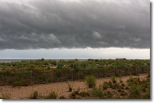
Weather Topic: What are Shelf Clouds?
Home - Education - Cloud Types - Shelf Clouds
 Next Topic: Sleet
A shelf cloud is similar to a wall cloud, but forms at the front
of a storm cloud, instead of at the rear, where wall clouds form.
A shelf cloud is caused by a series of events set into motion by the advancing
storm; first, cool air settles along the ground where precipitation has just fallen.
As the cool air is brought in, the warmer air is displaced, and rises above it,
because it is less dense. When the warmer air reaches the bottom of the storm cloud,
it begins to cool again, and the resulting condensation is a visible shelf cloud.
Next Topic: Sleet
Current conditions powered by WeatherAPI.com


