Weather Alert in Arizona
Flood Advisory issued August 26 at 12:44AM PDT until August 26 at 2:30AM PDT by NWS Las Vegas NV
AREAS AFFECTED: Mohave, AZ
DESCRIPTION: * WHAT...Flooding caused by excessive rainfall continues. * WHERE...A portion of northwest Arizona, including the following county, Mohave. * WHEN...Until 230 AM MST. * IMPACTS...Minor flooding in low-lying and poor drainage areas. * ADDITIONAL DETAILS... - At 1244 AM MST, Doppler radar indicated rain tapering off over eastern Mohave County. Minor flooding may still be ongoing in the advisory area. - Some locations that will experience flooding include... Wikieup, Valentine, Diamond M Ranch, Diamond Creek Campground, Blake Ranch Road, Dw Ranch Road, Hualapai Mountain Park, Wild Cow Campground, Grand Canyon Skywalk, Bar Ten Ranch, Toroweap Campground, Burro Creek Campground, Mt. Trumbull, Peach Springs and Tuweep. - This includes the following highways... Interstate 40 in Arizona between mile markers 61 and 93. the Colorado River between mile markers 169 and 268. - http://www.weather.gov/safety/flood
INSTRUCTION: Turn around, don't drown when encountering flooded roads. Most flood deaths occur in vehicles.
Want more detail? Get the Complete 7 Day and Night Detailed Forecast!
Current U.S. National Radar--Current
The Current National Weather Radar is shown below with a UTC Time (subtract 5 hours from UTC to get Eastern Time).

National Weather Forecast--Current
The Current National Weather Forecast and National Weather Map are shown below.

National Weather Forecast for Tomorrow
Tomorrow National Weather Forecast and Tomorrow National Weather Map are show below.

North America Water Vapor (Moisture)
This map shows recent moisture content over North America. Bright and colored areas show high moisture (ie, clouds); brown indicates very little moisture present; black indicates no moisture.

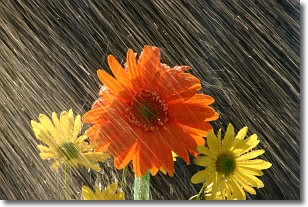
Weather Topic: What is Precipitation?
Home - Education - Precipitation - Precipitation
 Next Topic: Rain
Precipitation can refer to many different forms of water that
may fall from clouds. Precipitation occurs after a cloud has become saturated to
the point where its water particles are more dense than the air below the cloud.
In most cases, precipitation will reach the ground, but it is not uncommon for
precipitation to evaporate before it reaches the earth's surface.
When precipitation evaporates before it contacts the ground it is called Virga.
Graupel, hail, sleet, rain, drizzle, and snow are forms of precipitation, but fog
and mist are not considered precipitation because the water vapor which
constitutes them isn't dense enough to fall to the ground.
Next Topic: Rain
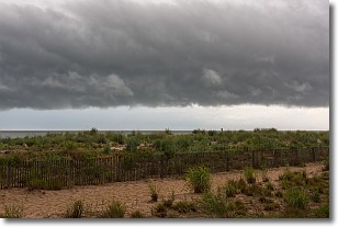
Weather Topic: What are Shelf Clouds?
Home - Education - Cloud Types - Shelf Clouds
 Next Topic: Sleet
A shelf cloud is similar to a wall cloud, but forms at the front
of a storm cloud, instead of at the rear, where wall clouds form.
A shelf cloud is caused by a series of events set into motion by the advancing
storm; first, cool air settles along the ground where precipitation has just fallen.
As the cool air is brought in, the warmer air is displaced, and rises above it,
because it is less dense. When the warmer air reaches the bottom of the storm cloud,
it begins to cool again, and the resulting condensation is a visible shelf cloud.
Next Topic: Sleet
Current conditions powered by WeatherAPI.com


