Weather Alert in Montana
Winter Storm Watch issued March 9 at 12:35PM MDT until March 14 at 12:00PM MDT by NWS Missoula MT
AREAS AFFECTED: Bitterroot/Sapphire Mountains
DESCRIPTION: * WHAT...Heavy snow and blowing snow possible above 5000 feet. There is a chance of major winter weather impacts. Total snow accumulations between 1 to 3 feet. Wind gusts of 40 to 60 mph, climbing to 60 to 80 mph along mountain ridgetops and crests. * WHERE...Highway 93 Sula to Lost Trail Pass and Lolo Pass. * WHEN...From Wednesday evening through Saturday morning. * IMPACTS...Visibilities may drop below 1/4 mile due to falling and blowing snow. The strong winds and weight of snow on tree limbs may down power lines and could cause sporadic power outages. Whiteout and blizzard conditions are possible in backcountry areas and may make travel treacherous and potentially life-threatening. For MAJOR winter weather impacts, expect considerable disruptions to normal activities. Dangerous or impossible traveling conditions. Avoid travel in the impacted areas if possible. Widespread closures and disruptions to infrastructure may occur. Strong winds could cause tree damage. * ADDITIONAL DETAILS...Snow levels will be climbing Wednesday into Thursday afternoon, reaching as high as 5,000 feet near Lolo Pass and 6,000 feet near Lost Trail Pass. The worst travel conditions are expected during the overnight and early morning periods.
INSTRUCTION: Monitor the latest forecasts for updates on this situation. Persons should consider delaying all travel. If travel is absolutely necessary, drive with extreme caution. Consider taking a winter storm kit along with you, including such items as tire chains, booster cables, flashlight, shovel, blankets and extra clothing. Also take water, a first aid kit, and anything else that would help you survive in case you become stranded. Do not touch downed lines and report any power outages to your electric company. Travel is highly discouraged due to slick roadways and the possibility of downed trees and power lines.
Want more detail? Get the Complete 7 Day and Night Detailed Forecast!
Current U.S. National Radar--Current
The Current National Weather Radar is shown below with a UTC Time (subtract 5 hours from UTC to get Eastern Time).

National Weather Forecast--Current
The Current National Weather Forecast and National Weather Map are shown below.

National Weather Forecast for Tomorrow
Tomorrow National Weather Forecast and Tomorrow National Weather Map are show below.

North America Water Vapor (Moisture)
This map shows recent moisture content over North America. Bright and colored areas show high moisture (ie, clouds); brown indicates very little moisture present; black indicates no moisture.

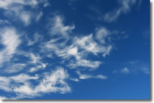
Weather Topic: What are Cirrostratus Clouds?
Home - Education - Cloud Types - Cirrostratus Clouds
 Next Topic: Cirrus Clouds
Cirrostratus clouds are high, thin clouds that form above
20,000 feet and are made mostly of ice crystals. They sometimes look like giant
feathers, horse tails, or curls of hair in the sky.
These clouds are pushed by the jet stream and can move at high speeds reaching
100 mph.
What do they indicate?
They indicate that a precipitation is likely within 24 hours.
Next Topic: Cirrus Clouds
Weather Topic: What is Condensation?
Home - Education - Precipitation - Condensation
 Next Topic: Contrails
Condensation is the process which creates clouds, and therefore
it is a crucial process in the water cycle.
Condensation is the change of matter from a state of gas into a state of liquid,
and it happens because water molecules release heat into the atmosphere and
become organized into a more closely packed structure, what we might see as
water droplets.
Water is always present in the air around us as a vapor, but it's too small for
us to see. When water undergoes the process of condensation it becomes organized
into visible water droplets. You've probably seen condensation happen before on the
surface of a cold drink!
Next Topic: Contrails
Current conditions powered by WeatherAPI.com


