Weather Alert in Oklahoma
Flood Warning issued August 27 at 2:16PM CDT until August 30 at 12:09PM CDT by NWS Tulsa OK
AREAS AFFECTED: Cherokee, OK
DESCRIPTION: ...The National Weather Service in Tulsa OK has issued a Flood Warning for the following rivers in Oklahoma... Illinois River near Watts affecting Delaware and Adair Counties. Illinois River at Chewey affecting Delaware, Adair and Cherokee Counties. Illinois River near Tahlequah affecting Cherokee County. * WHAT...Minor flooding is forecast. * WHERE...Illinois River near Tahlequah. * WHEN...From Friday afternoon to early Saturday afternoon. * IMPACTS...At 12.0 feet, minor flooding occurs from near Hanging Rock downstream towards Tahlequah. Extreme turbulence makes the river too hazardous for floating. * ADDITIONAL DETAILS... - At 1:30 PM CDT Wednesday the stage was 5.1 feet. - Forecast...The river is expected to rise above flood stage Friday afternoon to a crest of 12.2 feet early Saturday morning. It will then fall below flood stage Saturday morning. - Flood stage is 11.0 feet. - http://www.weather.gov/safety/flood
INSTRUCTION: N/A
Want more detail? Get the Complete 7 Day and Night Detailed Forecast!
Current U.S. National Radar--Current
The Current National Weather Radar is shown below with a UTC Time (subtract 5 hours from UTC to get Eastern Time).

National Weather Forecast--Current
The Current National Weather Forecast and National Weather Map are shown below.

National Weather Forecast for Tomorrow
Tomorrow National Weather Forecast and Tomorrow National Weather Map are show below.

North America Water Vapor (Moisture)
This map shows recent moisture content over North America. Bright and colored areas show high moisture (ie, clouds); brown indicates very little moisture present; black indicates no moisture.

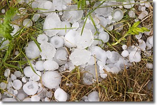
Weather Topic: What is Hail?
Home - Education - Precipitation - Hail
 Next Topic: Hole Punch Clouds
Hail is a form of precipitation which is recognized by large solid balls or
clumps of ice. Hail is created by thunderstorm clouds with strong updrafts of wind.
As the hailstones remain in the updraft, ice is deposited onto them until their
weight becomes heavy enough for them to fall to the earth's surface.
Hail storms can cause significant damage to crops, aircrafts, and man-made structures,
despite the fact that the duration is usually less than ten minutes.
Next Topic: Hole Punch Clouds
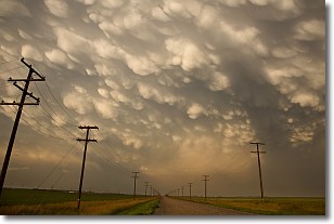
Weather Topic: What are Mammatus Clouds?
Home - Education - Cloud Types - Mammatus Clouds
 Next Topic: Nimbostratus Clouds
A mammatus cloud is a cloud with a unique feature which resembles
a web of pouches hanging along the base of the cloud.
In the United States, mammatus clouds tend to form in the warmer months, commonly
in the Midwest and eastern regions.
While they usually form at the bottom of a cumulonimbis cloud, they can also form
under altostratus, altocumulus, stratocumulus, and cirrus clouds. Mammatus clouds
warn that severe weather is close.
Next Topic: Nimbostratus Clouds
Current conditions powered by WeatherAPI.com


