Weather Alert in California
Winter Storm Watch issued February 15 at 9:07AM PST until February 19 at 9:00AM PST by NWS Los Angeles/Oxnard CA
AREAS AFFECTED: Western San Gabriel Mountains and Highway 14 Corridor; Western Antelope Valley Foothills; Eastern Antelope Valley Foothills
DESCRIPTION: * WHAT...Heavy snow possible. Total snow accumulations of 1 to 4 inches for 3500 to 4500 feet elevation, and 4 to 8 inches above 4500 feet elevation. Winds could gust as high as 50 mph. * WHERE...Eastern Antelope Valley Foothills, Western Antelope Valley Foothills, and Western San Gabriel Mountains and Highway 14 Corridor. * WHEN...From Tuesday evening through Thursday morning. * IMPACTS...Plan on slippery road conditions. The hazardous conditions could impact the Wednesday morning and evening commutes. Very strong winds could cause extensive tree damage.
INSTRUCTION: Monitor the latest forecasts for updates on this situation.
Want more detail? Get the Complete 7 Day and Night Detailed Forecast!
Current U.S. National Radar--Current
The Current National Weather Radar is shown below with a UTC Time (subtract 5 hours from UTC to get Eastern Time).

National Weather Forecast--Current
The Current National Weather Forecast and National Weather Map are shown below.

National Weather Forecast for Tomorrow
Tomorrow National Weather Forecast and Tomorrow National Weather Map are show below.

North America Water Vapor (Moisture)
This map shows recent moisture content over North America. Bright and colored areas show high moisture (ie, clouds); brown indicates very little moisture present; black indicates no moisture.

Weather Topic: What is Sleet?
Home - Education - Precipitation - Sleet
 Next Topic: Snow
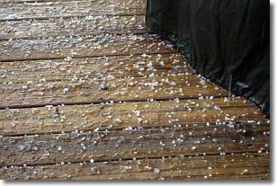
Sleet is a form of precipitation in which small ice pellets are the primary
components. These ice pellets are smaller and more translucent than hailstones,
and harder than graupel. Sleet is caused by specific atmospheric conditions and
therefore typically doesn't last for extended periods of time.
The condition which leads to sleet formation requires a warmer body of air to be
wedged in between two sub-freezing bodies of air. When snow falls through a warmer
layer of air it melts, and as it falls through the next sub-freezing body of air
it freezes again, forming ice pellets known as sleet. In some cases, water
droplets don't have time to freeze before reaching the surface and the result is
freezing rain.
Next Topic: Snow
Weather Topic: What are Stratocumulus Clouds?
Home - Education - Cloud Types - Stratocumulus Clouds
 Next Topic: Stratus Clouds
Stratocumulus clouds are similar to altocumulus clouds in their
fluffy appearance, but have a slightly darker shade due to their additional mass.
A good way to distinguish the two cloud types is to hold your hand out and measure
the size of an individual cloud; if it is the size of your thumb it is generally
an altocumulus cloud, if it is the size of your hand it is generally a
stratocumulus cloud.
It is uncommon for stratocumulus clouds to produce precipitation, but if they do
it is usually a light rain or snow.
Next Topic: Stratus Clouds
Current conditions powered by WeatherAPI.com


