Weather Alert in Alaska
Special Weather Statement issued September 7 at 2:50PM AKDT by NWS Juneau AK
AREAS AFFECTED: City and Borough of Yakutat; Municipality of Skagway; Haines Borough and Klukwan; Glacier Bay; Eastern Chichagof Island; Cape Fairweather to Lisianski Strait; City and Borough of Sitka; Admiralty Island; City and Borough of Juneau; Petersburg Borough; Western Kupreanof and Kuiu Island; Prince of Wales Island; City and Borough of Wrangell; Ketchikan Gateway Borough; Annette Island
DESCRIPTION: A WET FALL STORM WILL BE IMPACTING THE PANHANDLE EARLY WEDNESDAY INTO THURSDAY NIGHT DROPPING AROUND 2 TO 4 INCHES OF RAIN FOR THE LOWER ELEVATIONS AND UP TO 6 INCHES FOR THE HIGHER ELEVATIONS OF THE PANHANDLE. FREEZING LEVELS ARE STILL HIGH AROUND 8000 TO 9000 FT ACROSS THE AREA SO MOST OF THE PRECIPITATION THAT FALLS AT ELEVATION WILL BE RAIN. AREA RIVERS AND STREAMS ARE EXPECTED TO EXPERIENCE RISES IN WATER LEVELS AND INCREASED FLOWS WEDNESDAY INTO THURSDAY IN RESPONSE TO THE HEAVIER RAINFALL, AND MAY STAY HIGH INTO FRIDAY. STAY TUNED FOR MORE UPDATES AS WE GET CLOSER TO THE EVENT.
INSTRUCTION: N/A
Want more detail? Get the Complete 7 Day and Night Detailed Forecast!
Current U.S. National Radar--Current
The Current National Weather Radar is shown below with a UTC Time (subtract 5 hours from UTC to get Eastern Time).

National Weather Forecast--Current
The Current National Weather Forecast and National Weather Map are shown below.

National Weather Forecast for Tomorrow
Tomorrow National Weather Forecast and Tomorrow National Weather Map are show below.

North America Water Vapor (Moisture)
This map shows recent moisture content over North America. Bright and colored areas show high moisture (ie, clouds); brown indicates very little moisture present; black indicates no moisture.

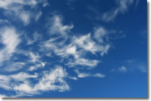
Weather Topic: What are Altostratus Clouds?
Home - Education - Cloud Types - Altostratus Clouds
 Next Topic: Cirrocumulus Clouds
Altostratus clouds form at mid to high-level altitudes
(between 2 and 7 km) and are created by a warm, stable air mass which causes
water vapor
to condense as it rise through the atmosphere. Usually altostratus clouds are
featureless sheets characterized by a uniform color.
In some cases, wind punching through the cloud formation may give it a waved
appearance, called altostratus undulatus. Altostratus clouds
are commonly seen with other cloud formations accompanying them.
Next Topic: Cirrocumulus Clouds
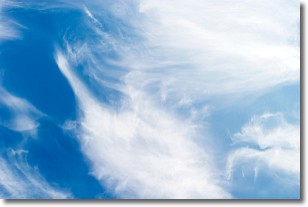
Weather Topic: What are Cirrostratus Clouds?
Home - Education - Cloud Types - Cirrostratus Clouds
 Next Topic: Cirrus Clouds
Cirrostratus clouds are high, thin clouds that form above
20,000 feet and are made mostly of ice crystals. They sometimes look like giant
feathers, horse tails, or curls of hair in the sky.
These clouds are pushed by the jet stream and can move at high speeds reaching
100 mph.
What do they indicate?
They indicate that a precipitation is likely within 24 hours.
Next Topic: Cirrus Clouds
Current conditions powered by WeatherAPI.com


