Weather Alert in Montana
Winter Storm Watch issued March 31 at 10:34AM MDT until April 3 at 6:00AM MDT by NWS Missoula MT
AREAS AFFECTED: Bitterroot/Sapphire Mountains; Butte/Blackfoot Region; Potomac/Seeley Lake Region
DESCRIPTION: * WHAT...Heavy snow possible. There is a chance of moderate to major winter weather impacts. Total snow accumulations between 6 and 12 inches possible for terrain above 5500 feet, including MacDonald Pass, Homestake Pass, Lost Trail Pass and Lolo Pass. 2 to 6 inches possible down to 3000 feet, including Butte, Seeley Lake and Anaconda. Winds could gust as high as 35 mph. * WHERE...Butte, Highway 12 Garrison to Elliston, I-90 East Missoula to Bearmouth, Georgetown Lake, Highway 93 Sula to Lost Trail Pass, Highway 83 Seeley Lake to Condon, Lolo Pass, MacDonald Pass, Homestake Pass, and Highway 200 Bonner to Greenough. * WHEN...From Thursday morning through late Thursday night. * IMPACTS...For MODERATE winter weather impacts, expect disruptions to normal activities. Hazardous traveling conditions. Use extra caution while driving. Closures and disruptions to infrastructure may occur. For MAJOR winter weather impacts, expect considerable disruptions to normal activities. Dangerous or impossible traveling conditions. Avoid travel in the impacted areas if possible. Widespread closures and disruptions to infrastructure may occur. The hazardous conditions could impact the Thursday morning and evening commutes, especially over higher passes. * ADDITIONAL DETAILS...Heavy, wet snow may cause power outages and tree damage.
INSTRUCTION: Monitor the latest forecasts for updates on this situation.
Want more detail? Get the Complete 7 Day and Night Detailed Forecast!
Current U.S. National Radar--Current
The Current National Weather Radar is shown below with a UTC Time (subtract 5 hours from UTC to get Eastern Time).

National Weather Forecast--Current
The Current National Weather Forecast and National Weather Map are shown below.

National Weather Forecast for Tomorrow
Tomorrow National Weather Forecast and Tomorrow National Weather Map are show below.

North America Water Vapor (Moisture)
This map shows recent moisture content over North America. Bright and colored areas show high moisture (ie, clouds); brown indicates very little moisture present; black indicates no moisture.

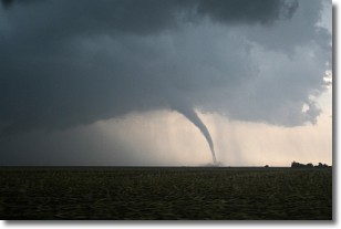
Weather Topic: What are Wall Clouds?
Home - Education - Cloud Types - Wall Clouds
 Next Topic: Altocumulus Clouds
A wall cloud forms underneath the base of a cumulonimbus cloud,
and can be a hotbed for deadly tornadoes.
Wall clouds are formed by air flowing into the cumulonimbus clouds, which can
result in the wall cloud descending from the base of the cumulonimbus cloud, or
rising fractus clouds which join to the base of the storm cloud as the wall cloud
takes shape.
Wall clouds can be very large, and in the Northern Hemisphere they generally
form at the southern edge of cumulonimbus clouds.
Next Topic: Altocumulus Clouds
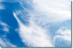
Weather Topic: What are Altostratus Clouds?
Home - Education - Cloud Types - Altostratus Clouds
 Next Topic: Cirrocumulus Clouds
Altostratus clouds form at mid to high-level altitudes
(between 2 and 7 km) and are created by a warm, stable air mass which causes
water vapor
to condense as it rise through the atmosphere. Usually altostratus clouds are
featureless sheets characterized by a uniform color.
In some cases, wind punching through the cloud formation may give it a waved
appearance, called altostratus undulatus. Altostratus clouds
are commonly seen with other cloud formations accompanying them.
Next Topic: Cirrocumulus Clouds
Current conditions powered by WeatherAPI.com


