Weather Alert in Oregon
Winter Storm Watch issued March 30 at 11:39PM PDT until April 2 at 5:00PM PDT by NWS Medford OR
AREAS AFFECTED: Eastern Douglas County Foothills; South Central Oregon Cascades; Siskiyou Mountains and Southern Oregon Cascades
DESCRIPTION: * WHAT...Heavy snow possible. Total snow accumulations 10 to 20 inches possible. Winds could gust as high as 40 mph over high and exposed terrain. * WHERE...The southern Oregon Cascades north of Howard Prairie Lake, and the eastern Douglas County Foothills above 3000 ft, including the passes along highways 140, 62, 138, 230, and 58. * WHEN...From late Tuesday night through Thursday afternoon. * IMPACTS...Travel may be very difficult to impossible. The hazardous conditions could impact the Wednesday morning and evening commutes. Gusty winds could bring down tree branches.
INSTRUCTION: Monitor the latest forecasts for updates on this situation.
Want more detail? Get the Complete 7 Day and Night Detailed Forecast!
Current U.S. National Radar--Current
The Current National Weather Radar is shown below with a UTC Time (subtract 5 hours from UTC to get Eastern Time).

National Weather Forecast--Current
The Current National Weather Forecast and National Weather Map are shown below.

National Weather Forecast for Tomorrow
Tomorrow National Weather Forecast and Tomorrow National Weather Map are show below.

North America Water Vapor (Moisture)
This map shows recent moisture content over North America. Bright and colored areas show high moisture (ie, clouds); brown indicates very little moisture present; black indicates no moisture.

Weather Topic: What is Condensation?
Home - Education - Precipitation - Condensation
 Next Topic: Contrails
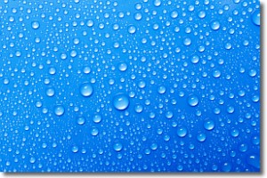
Condensation is the process which creates clouds, and therefore
it is a crucial process in the water cycle.
Condensation is the change of matter from a state of gas into a state of liquid,
and it happens because water molecules release heat into the atmosphere and
become organized into a more closely packed structure, what we might see as
water droplets.
Water is always present in the air around us as a vapor, but it's too small for
us to see. When water undergoes the process of condensation it becomes organized
into visible water droplets. You've probably seen condensation happen before on the
surface of a cold drink!
Next Topic: Contrails
Weather Topic: What are Cumulonimbus Clouds?
Home - Education - Cloud Types - Cumulonimbus Clouds
 Next Topic: Cumulus Clouds
The final form taken by a growing cumulus cloud is the
cumulonimbus cloud, which is very tall and dense.
The tower of a cumulonimbus cloud can soar 23 km into the atmosphere, although
most commonly they stop growing at an altitude of 6 km.
Even small cumulonimbus clouds appear very large in comparison to other cloud types.
They can signal the approach of stormy weather, such as thunderstorms or blizzards.
Next Topic: Cumulus Clouds
Current conditions powered by WeatherAPI.com


