Weather Alert in Alaska
Flood Watch issued August 26 at 3:49PM AKDT until August 28 at 10:00AM AKDT by NWS Anchorage AK
AREAS AFFECTED: Kuskokwim Valley West; Kuskokwim Valley East; Interior Kuskokwim Delta; Western Capes; Northern Bristol Bay Coast; Inland Bristol Bay
DESCRIPTION: * WHAT...Flooding caused by excessive rainfall continues to be possible. * WHERE...Interior Kuskokwim Delta, Kuskokwim Valley, Northern Bristol Bay Coast, Inland Bristol Bay, and Western Capes. * WHEN...Through Thursday morning. * IMPACTS...Excessive runoff may result in flooding of small streams and other low-lying and flood-prone locations. Significant ponding of water, areal flooding, and erosion may occur in poor drainage areas. Flooding is not expected along the main Kuskokwim River and other major rivers. * ADDITIONAL DETAILS... - About 0.5 to 1 inches of rain have fallen since Monday, with some areas receiving 1.5 inches or more. An additional 1 to 2.5 inches of rain are forecast through Thursday from the front currently moving through Southwest Alaska, and from a North Pacific storm arriving later on Wednesday. There is still uncertainty with the track of the storm on Wednesday, and whether rain from this storm will spread west to Bethel or remain east of Dillingham. As such, confidence is low to medium regarding forecast rain amounts. - Http://www.weather.gov/safety/flood
INSTRUCTION: You should monitor later forecasts and be alert for possible Flood Warnings. Those living in areas prone to flooding should be prepared to take action should flooding develop.
Want more detail? Get the Complete 7 Day and Night Detailed Forecast!
Current U.S. National Radar--Current
The Current National Weather Radar is shown below with a UTC Time (subtract 5 hours from UTC to get Eastern Time).

National Weather Forecast--Current
The Current National Weather Forecast and National Weather Map are shown below.

National Weather Forecast for Tomorrow
Tomorrow National Weather Forecast and Tomorrow National Weather Map are show below.

North America Water Vapor (Moisture)
This map shows recent moisture content over North America. Bright and colored areas show high moisture (ie, clouds); brown indicates very little moisture present; black indicates no moisture.

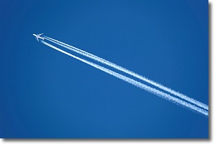
Weather Topic: What are Contrails?
Home - Education - Cloud Types - Contrails
 Next Topic: Cumulonimbus Clouds
A contrail is an artificial cloud, created by the passing of an
aircraft.
Contrails form because water vapor in the exhaust of aircraft engines is suspended
in the air under certain temperatures and humidity conditions. These contrails
are called exhaust contrails.
Another type of contrail can form due to a temporary reduction in air pressure
moving over the plane's surface, causing condensation.
These are called aerodynamic contrails.
When you can see your breath on a cold day, it is also because of condensation.
The reason contrails last longer than the condensation from your breath is
because the water in contrails freezes into ice particles.
Next Topic: Cumulonimbus Clouds
Weather Topic: What are Cumulus Clouds?
Home - Education - Cloud Types - Cumulus Clouds
 Next Topic: Drizzle
Cumulus clouds are fluffy and textured with rounded tops, and
may have flat bottoms. The border of a cumulus cloud
is clearly defined, and can have the appearance of cotton or cauliflower.
Cumulus clouds form at low altitudes (rarely above 2 km) but can grow very tall,
becoming cumulus congestus and possibly the even taller cumulonimbus clouds.
When cumulus clouds become taller, they have a greater chance of producing precipitation.
Next Topic: Drizzle
Current conditions powered by WeatherAPI.com


