Weather Alert in Ohio
Flood Warning issued March 6 at 9:49PM EST until March 7 at 7:00AM EST by NWS Charleston WV
AREAS AFFECTED: Athens, OH; Gallia, OH; Jackson, OH; Meigs, OH; Vinton, OH; Washington, OH
DESCRIPTION: * WHAT...Flooding caused by excessive rainfall continues. * WHERE...A portion of southeast Ohio, including the following counties, Athens, Gallia, Jackson, Meigs, Vinton and Washington. * WHEN...Until 700 AM EST Saturday. * IMPACTS...Flooding of creeks and other low-lying and flood-prone locations is occurring. Low-water crossings are inundated with water and may not be passable. * ADDITIONAL DETAILS... - At 946 PM EST, several county roads remain closed due to residual flooding from area creeks, particularly in low-lying areas. Expect high water to linger overnight even though the creeks have receded to within their respective banks. This includes low-lying areas along the lower portions of the Hocking River and Shade Rivers. - Some locations that will experience flooding include... Wellston, Mcarthur, Lake Hope State Park, Middleport, and Chester. - http://www.weather.gov/safety/flood
INSTRUCTION: Turn around, don't drown when encountering flooded roads. Most flood deaths occur in vehicles. Be especially cautious at night when it is harder to recognize the dangers of flooding. In hilly terrain there are hundreds of low water crossings which are potentially dangerous in heavy rain. Do not attempt to cross flooded roads. Find an alternate route. Report flooding to the National Weather Service by calling toll free, 800 401 9535, when you can do so safely.
Want more detail? Get the Complete 7 Day and Night Detailed Forecast!
Current U.S. National Radar--Current
The Current National Weather Radar is shown below with a UTC Time (subtract 5 hours from UTC to get Eastern Time).

National Weather Forecast--Current
The Current National Weather Forecast and National Weather Map are shown below.

National Weather Forecast for Tomorrow
Tomorrow National Weather Forecast and Tomorrow National Weather Map are show below.

North America Water Vapor (Moisture)
This map shows recent moisture content over North America. Bright and colored areas show high moisture (ie, clouds); brown indicates very little moisture present; black indicates no moisture.

Weather Topic: What is Freezing Rain?
Home - Education - Precipitation - Freezing Rain
 Next Topic: Graupel
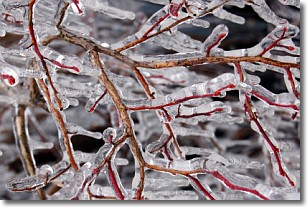
Freezing rain is a condition where precipitation which has fallen in the form of
water droplets reaches temperatures which are below freezing and freezes upon
coming into contact
with surface objects. The result of this precipitation is a glaze of ice which
can be damaging to plants and man-made structures. A severe onset of freezing
rain which results in a very thick glaze of ice is known as an ice storm.
Next Topic: Graupel
Weather Topic: What is Hail?
Home - Education - Precipitation - Hail
 Next Topic: Hole Punch Clouds
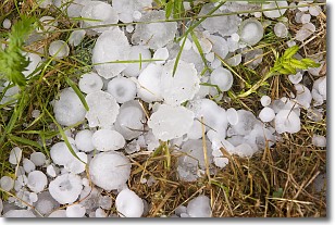
Hail is a form of precipitation which is recognized by large solid balls or
clumps of ice. Hail is created by thunderstorm clouds with strong updrafts of wind.
As the hailstones remain in the updraft, ice is deposited onto them until their
weight becomes heavy enough for them to fall to the earth's surface.
Hail storms can cause significant damage to crops, aircrafts, and man-made structures,
despite the fact that the duration is usually less than ten minutes.
Next Topic: Hole Punch Clouds
Current conditions powered by WeatherAPI.com


