Weather Alert in New Mexico
Hydrologic Outlook issued August 27 at 10:52AM MDT by NWS Albuquerque NM
AREAS AFFECTED: Colfax, NM; Mora, NM; San Miguel, NM; Taos, NM
DESCRIPTION: ESFABQ Heightened Risk of River and Stream Flooding During Storm Events Through the Holiday Weekend. Repeated rounds of heavy rainfall in the area over the last several days have saturated the soils and raised the baseflow of rivers and streams in the area. We have reports of streams near the Mora, Sapello, Pecos and Vermejo river rising out of their banks, with additional reports of flowing water and debris across roads such as 518. These waterways will be extremely vulnerable to further rounds of precipitation, which we are expecting over the next week as a surge of deep monsoon moisture moves through the area. Expect further rises and impacts to nearby roads and low water crossings. Stay aware of any flash flood or river flood warnings that are issued. Exercise caution along riverbanks and watch out for potential mudslides across roads. For questions or comments about this outlook, you can contact Andrew Mangham, Senior Service Hydrologist, at 505-244-9150 x 228 or via e- mail at andrew.mangham@noaa.gov.
INSTRUCTION: N/A
Want more detail? Get the Complete 7 Day and Night Detailed Forecast!
Current U.S. National Radar--Current
The Current National Weather Radar is shown below with a UTC Time (subtract 5 hours from UTC to get Eastern Time).

National Weather Forecast--Current
The Current National Weather Forecast and National Weather Map are shown below.

National Weather Forecast for Tomorrow
Tomorrow National Weather Forecast and Tomorrow National Weather Map are show below.

North America Water Vapor (Moisture)
This map shows recent moisture content over North America. Bright and colored areas show high moisture (ie, clouds); brown indicates very little moisture present; black indicates no moisture.

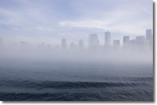
Weather Topic: What is Fog?
Home - Education - Cloud Types - Fog
 Next Topic: Fractus Clouds
Fog is technically a type of stratus cloud, which lies along the
ground and obscures visibility.
It is usually created when humidity in the air condenses into tiny water droplets.
Because of this, some places are more prone to foggy weather, such as regions
close to a body of water.
Fog is similar to mist; both are the appearance of water droplets suspended in
the air, but fog is the term applied to the condition when visibility is less than 1 km.
Next Topic: Fractus Clouds
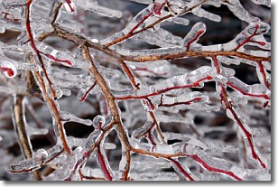
Weather Topic: What is Freezing Rain?
Home - Education - Precipitation - Freezing Rain
 Next Topic: Graupel
Freezing rain is a condition where precipitation which has fallen in the form of
water droplets reaches temperatures which are below freezing and freezes upon
coming into contact
with surface objects. The result of this precipitation is a glaze of ice which
can be damaging to plants and man-made structures. A severe onset of freezing
rain which results in a very thick glaze of ice is known as an ice storm.
Next Topic: Graupel
Current conditions powered by WeatherAPI.com


