Weather Alert in Connecticut
Special Weather Statement issued March 6 at 12:28PM EST by NWS Boston/Norton MA
AREAS AFFECTED: Hartford; Tolland; Windham; Western Franklin; Eastern Franklin; Northern Worcester; Central Middlesex County; Western Essex; Eastern Essex; Western Hampshire; Western Hampden; Eastern Hampshire; Eastern Hampden; Southern Worcester; Western Norfolk; Southeast Middlesex; Suffolk; Eastern Norfolk; Northern Bristol; Western Plymouth; Eastern Plymouth; Southern Bristol; Southern Plymouth; Barnstable; Dukes; Northwest Middlesex County; Northwest Providence; Southeast Providence; Western Kent; Eastern Kent; Bristol; Washington; Newport
DESCRIPTION: Spotty freezing drizzle is possible through tonight north of the Mass Pike and in the higher elevations. Be alert for icy spots on untreated roads. Across the rest of southern New England, including areas near the coast, temperatures will fall to around freezing later tonight into early Saturday morning. Leftover moisture may produce icy spots on untreated roads in these areas as well. Plan on allowing extra travel time and be especially careful on bridges and overpasses. Temperatures will warm above freezing Saturday morning.
INSTRUCTION: N/A
Want more detail? Get the Complete 7 Day and Night Detailed Forecast!
Current U.S. National Radar--Current
The Current National Weather Radar is shown below with a UTC Time (subtract 5 hours from UTC to get Eastern Time).

National Weather Forecast--Current
The Current National Weather Forecast and National Weather Map are shown below.

National Weather Forecast for Tomorrow
Tomorrow National Weather Forecast and Tomorrow National Weather Map are show below.

North America Water Vapor (Moisture)
This map shows recent moisture content over North America. Bright and colored areas show high moisture (ie, clouds); brown indicates very little moisture present; black indicates no moisture.

Weather Topic: What is Hail?
Home - Education - Precipitation - Hail
 Next Topic: Hole Punch Clouds
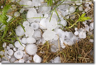
Hail is a form of precipitation which is recognized by large solid balls or
clumps of ice. Hail is created by thunderstorm clouds with strong updrafts of wind.
As the hailstones remain in the updraft, ice is deposited onto them until their
weight becomes heavy enough for them to fall to the earth's surface.
Hail storms can cause significant damage to crops, aircrafts, and man-made structures,
despite the fact that the duration is usually less than ten minutes.
Next Topic: Hole Punch Clouds
Weather Topic: What are Mammatus Clouds?
Home - Education - Cloud Types - Mammatus Clouds
 Next Topic: Nimbostratus Clouds
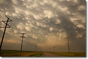
A mammatus cloud is a cloud with a unique feature which resembles
a web of pouches hanging along the base of the cloud.
In the United States, mammatus clouds tend to form in the warmer months, commonly
in the Midwest and eastern regions.
While they usually form at the bottom of a cumulonimbis cloud, they can also form
under altostratus, altocumulus, stratocumulus, and cirrus clouds. Mammatus clouds
warn that severe weather is close.
Next Topic: Nimbostratus Clouds
Current conditions powered by WeatherAPI.com


