Weather Alert in California
Winter Storm Watch issued February 13 at 11:44AM PST until February 18 at 10:00AM PST by NWS Eureka CA
AREAS AFFECTED: Northern Trinity; Southern Trinity
DESCRIPTION: * WHAT...Heavy snow possible. Total snow accumulation between 6 to 10 inches possible above 2000 feet. Total snow accumulations between 1 and 2.5 feet possible for elevations above 3000 feet. * WHERE...Trinity County. * WHEN...From Sunday morning through Wednesday morning. * IMPACTS...Travel could be very difficult to impossible. Tire chains may be necessary if travelling through mountain passes. * ADDITIONAL DETAILS...Snow levels will remain above 4500 feet Sunday through Monday, dropping to 2000 feet Monday night into Tuesday. There is a potential for snow levels as low as 1500 feet with the heaviest snowfall. The heaviest snowfall rates are expected late Monday through Tuesday morning.
INSTRUCTION: Monitor the latest forecasts for updates on this situation.
Want more detail? Get the Complete 7 Day and Night Detailed Forecast!
Current U.S. National Radar--Current
The Current National Weather Radar is shown below with a UTC Time (subtract 5 hours from UTC to get Eastern Time).

National Weather Forecast--Current
The Current National Weather Forecast and National Weather Map are shown below.

National Weather Forecast for Tomorrow
Tomorrow National Weather Forecast and Tomorrow National Weather Map are show below.

North America Water Vapor (Moisture)
This map shows recent moisture content over North America. Bright and colored areas show high moisture (ie, clouds); brown indicates very little moisture present; black indicates no moisture.

Weather Topic: What is Hail?
Home - Education - Precipitation - Hail
 Next Topic: Hole Punch Clouds
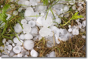
Hail is a form of precipitation which is recognized by large solid balls or
clumps of ice. Hail is created by thunderstorm clouds with strong updrafts of wind.
As the hailstones remain in the updraft, ice is deposited onto them until their
weight becomes heavy enough for them to fall to the earth's surface.
Hail storms can cause significant damage to crops, aircrafts, and man-made structures,
despite the fact that the duration is usually less than ten minutes.
Next Topic: Hole Punch Clouds
Weather Topic: What are Mammatus Clouds?
Home - Education - Cloud Types - Mammatus Clouds
 Next Topic: Nimbostratus Clouds
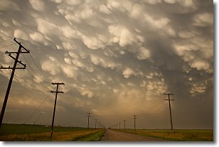
A mammatus cloud is a cloud with a unique feature which resembles
a web of pouches hanging along the base of the cloud.
In the United States, mammatus clouds tend to form in the warmer months, commonly
in the Midwest and eastern regions.
While they usually form at the bottom of a cumulonimbis cloud, they can also form
under altostratus, altocumulus, stratocumulus, and cirrus clouds. Mammatus clouds
warn that severe weather is close.
Next Topic: Nimbostratus Clouds
Current conditions powered by WeatherAPI.com


