Weather Alert in Alaska
Winter Weather Advisory issued February 28 at 1:51PM AKST until March 2 at 6:00AM AKST by NWS Juneau AK
AREAS AFFECTED: Prince of Wales Island
DESCRIPTION: ...CENTRAL AND SOUTHERN PANHANDLE SNOW SATURDAY WITH POTENTIAL FOR MORE SNOW SUNDAY... Steady snowfall continues across a majority of the panhandle and will continue to pick up as the low moves into the eastern gulf through Saturday afternoon. Later in the afternoon and evening, south to southwest wind are expected to cause temperatures to warm over the southern outer coast with precipitation becoming a mix or changing to all rain. Around the same time, snow will end on the NW side of the low, from Sitka to Juneau and northward. Moisture will decrease overnight Saturday across the south, but then redevelop on Sunday as another system moves in. The rain/snow line will likely hover in vicinity of Sumner Strait Sunday into Monday with additional heavy snow expected for the Petersburg and Wrangell areas and lighter snow northward. A separate low pressure system looks to affect the region on Tuesday with potential for snow to push northward once again. * WHAT...For the first Winter Weather Advisory, snow. Additional snow accumulations of 1 to 3 inches. For the second Winter Weather Advisory, snow expected. Total snow accumulations of up to 8 inches. * WHERE...Prince of Wales Island. * WHEN...For the first Winter Weather Advisory, until 9 PM AKST this evening. For the second Winter Weather Advisory, from 6 AM Sunday to 6 AM AKST Monday. * IMPACTS...Travel will be difficult. The hazardous conditions could impact the morning commute. * ADDITIONAL DETAILS...Heaviest snowfall rates are expected through the afternoon. Another band of snow is expected to develop along the northern part of the island Sunday. Snowfall beginning Sunday should be limited to the northern part of the island and upper elevation highways. The southern half of the panhandle should see warming and either a rain snow mix with minimal accumulations or straight rain.
INSTRUCTION: Slow down and use caution while traveling. People are urged to prepare their property before the onset of winter weather. For the latest road conditions, where available, call 5 1 1 or visit 511.alaska.gov.
Want more detail? Get the Complete 7 Day and Night Detailed Forecast!
Current U.S. National Radar--Current
The Current National Weather Radar is shown below with a UTC Time (subtract 5 hours from UTC to get Eastern Time).

National Weather Forecast--Current
The Current National Weather Forecast and National Weather Map are shown below.

National Weather Forecast for Tomorrow
Tomorrow National Weather Forecast and Tomorrow National Weather Map are show below.

North America Water Vapor (Moisture)
This map shows recent moisture content over North America. Bright and colored areas show high moisture (ie, clouds); brown indicates very little moisture present; black indicates no moisture.

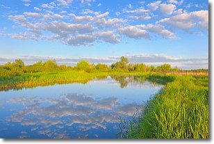
Weather Topic: What are Stratocumulus Clouds?
Home - Education - Cloud Types - Stratocumulus Clouds
 Next Topic: Stratus Clouds
Stratocumulus clouds are similar to altocumulus clouds in their
fluffy appearance, but have a slightly darker shade due to their additional mass.
A good way to distinguish the two cloud types is to hold your hand out and measure
the size of an individual cloud; if it is the size of your thumb it is generally
an altocumulus cloud, if it is the size of your hand it is generally a
stratocumulus cloud.
It is uncommon for stratocumulus clouds to produce precipitation, but if they do
it is usually a light rain or snow.
Next Topic: Stratus Clouds
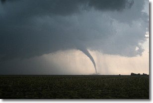
Weather Topic: What are Wall Clouds?
Home - Education - Cloud Types - Wall Clouds
 Next Topic: Altocumulus Clouds
A wall cloud forms underneath the base of a cumulonimbus cloud,
and can be a hotbed for deadly tornadoes.
Wall clouds are formed by air flowing into the cumulonimbus clouds, which can
result in the wall cloud descending from the base of the cumulonimbus cloud, or
rising fractus clouds which join to the base of the storm cloud as the wall cloud
takes shape.
Wall clouds can be very large, and in the Northern Hemisphere they generally
form at the southern edge of cumulonimbus clouds.
Next Topic: Altocumulus Clouds
Current conditions powered by WeatherAPI.com


