Weather Alert in Alaska
Winter Weather Advisory issued February 28 at 1:51PM AKST until February 28 at 9:00PM AKST by NWS Juneau AK
AREAS AFFECTED: Admiralty Island
DESCRIPTION: ...CENTRAL AND SOUTHERN PANHANDLE SNOW SATURDAY WITH POTENTIAL FOR MORE SNOW SUNDAY... Steady snowfall continues across a majority of the panhandle and will continue to pick up as the low moves into the eastern gulf through Saturday afternoon. Later in the afternoon and evening, south to southwest wind are expected to cause temperatures to warm over the southern outer coast with precipitation becoming a mix or changing to all rain. Around the same time, snow will end on the NW side of the low, from Sitka to Juneau and northward. Moisture will decrease overnight Saturday across the south, but then redevelop on Sunday as another system moves in. The rain/snow line will likely hover in vicinity of Sumner Strait Sunday into Monday with additional heavy snow expected for the Petersburg and Wrangell areas and lighter snow northward. A separate low pressure system looks to affect the region on Tuesday with potential for snow to push northward once again. * WHAT...Snow. Additional snow accumulations of 2 to 4 inches. * WHERE...Admiralty Island. * WHEN...Until 9 PM AKST this evening. * IMPACTS...Travel could be difficult. * ADDITIONAL DETAILS...Heaviest snowfall rates are still expected through the afternoon. We are continuing to monitor another low pressure system that is likely to bring more snow to the area Tuesday.
INSTRUCTION: Slow down and use caution while traveling. People are urged to prepare their property before the onset of winter weather.
Want more detail? Get the Complete 7 Day and Night Detailed Forecast!
Current U.S. National Radar--Current
The Current National Weather Radar is shown below with a UTC Time (subtract 5 hours from UTC to get Eastern Time).

National Weather Forecast--Current
The Current National Weather Forecast and National Weather Map are shown below.

National Weather Forecast for Tomorrow
Tomorrow National Weather Forecast and Tomorrow National Weather Map are show below.

North America Water Vapor (Moisture)
This map shows recent moisture content over North America. Bright and colored areas show high moisture (ie, clouds); brown indicates very little moisture present; black indicates no moisture.

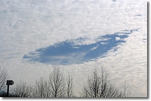
Weather Topic: What are Hole Punch Clouds?
Home - Education - Cloud Types - Hole Punch Clouds
 Next Topic: Mammatus Clouds
A hole punch cloud is an unusual occurrence when a disk-shaped
hole appears in a cirrostratus, cirrocumulus, or altocumulus cloud.
When part of the cloud forms ice crystals, water droplets in the surrounding area
of the cloud evaporate. The effect of this process produces a large elliptical
gap in the cloud. The hole punch cloud formation is rare, but it is not specific
to any geographic area.
Other names which have been used to describe this phenomena include fallstreak hole,
skypunch, and cloud hole.
Next Topic: Mammatus Clouds
Weather Topic: What are Nimbostratus Clouds?
Home - Education - Cloud Types - Nimbostratus Clouds
 Next Topic: Precipitation
A nimbostratus cloud is similar to a stratus cloud in its formless,
smooth appearance. However, a nimbostratus cloud is darker than a stratus cloud,
because it is thicker.
Unlike a stratus cloud, a nimbostratus cloud typically brings with it the threat
of moderate to heavy precipitation. In some cases, the precipitation may evaporate
before reaching the ground, a phenomenon known as virga.
Next Topic: Precipitation
Current conditions powered by WeatherAPI.com


