Weather Alert in Idaho
Flash Flood Warning issued August 26 at 6:05PM MDT until August 26 at 9:00PM MDT by NWS Boise ID
AREAS AFFECTED: Boise, ID
DESCRIPTION: FFWBOI The National Weather Service in Boise has issued a * Flash Flood Warning for... East Central Boise County in southwestern Idaho... * Until 900 PM MDT. * At 605 PM MDT, Boise County law enforcement reported numerous 911 calls about rock slides and standing water on Idaho State Highway 21 between Lowman and Grandjean. Flash flooding is ongoing. HAZARD...Flash flooding caused by thunderstorms. SOURCE...Law enforcement reported. IMPACT...Flash flooding of small creeks and streams, as well as other poor drainage and low-lying areas. Rock slides were reported on Idaho State Highway 21 at mileposts 72 and 76-77. Three feet of water was reported on the road at milepost 80.
INSTRUCTION: Stay away or be swept away. River banks and culverts can become unstable and unsafe. In hilly terrain there are hundreds of low water crossings which are potentially dangerous in heavy rain. Do not attempt to cross flooded roads. Find an alternate route.
Want more detail? Get the Complete 7 Day and Night Detailed Forecast!
Current U.S. National Radar--Current
The Current National Weather Radar is shown below with a UTC Time (subtract 5 hours from UTC to get Eastern Time).

National Weather Forecast--Current
The Current National Weather Forecast and National Weather Map are shown below.

National Weather Forecast for Tomorrow
Tomorrow National Weather Forecast and Tomorrow National Weather Map are show below.

North America Water Vapor (Moisture)
This map shows recent moisture content over North America. Bright and colored areas show high moisture (ie, clouds); brown indicates very little moisture present; black indicates no moisture.

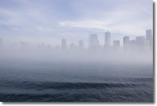
Weather Topic: What is Fog?
Home - Education - Cloud Types - Fog
 Next Topic: Fractus Clouds
Fog is technically a type of stratus cloud, which lies along the
ground and obscures visibility.
It is usually created when humidity in the air condenses into tiny water droplets.
Because of this, some places are more prone to foggy weather, such as regions
close to a body of water.
Fog is similar to mist; both are the appearance of water droplets suspended in
the air, but fog is the term applied to the condition when visibility is less than 1 km.
Next Topic: Fractus Clouds
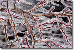
Weather Topic: What is Freezing Rain?
Home - Education - Precipitation - Freezing Rain
 Next Topic: Graupel
Freezing rain is a condition where precipitation which has fallen in the form of
water droplets reaches temperatures which are below freezing and freezes upon
coming into contact
with surface objects. The result of this precipitation is a glaze of ice which
can be damaging to plants and man-made structures. A severe onset of freezing
rain which results in a very thick glaze of ice is known as an ice storm.
Next Topic: Graupel
Current conditions powered by WeatherAPI.com


