Weather Alert in Montana
Avalanche Warning issued February 24 at 9:37AM MST by NWS Missoula MT
AREAS AFFECTED: Bitterroot/Sapphire Mountains; Potomac/Seeley Lake Region
DESCRIPTION: AVWMSO The following message is transmitted at the request of the West Central Montana Avalanche Center Missoula MT. ...AVALANCHE WARNING ISSUED BY THE WEST CENTRAL MONTANA AVALANCHE CENTER... 08:23 MST Tue Feb 24 2026 The West Central Montana Avalanche Center in Missoula has issued a BACKCOUNTRY AVALANCHE WARNING for the following areas: NWS Missoula MT - MTZ006 (MTZ006)...MTZ043 (MTZ043) * WHAT...A strong storm with new and windblown snow has created dangerous avalanche conditions. This new snow will likely overload buried weak layers and lead to large natural avalanches. Travel in avalanche terrain is not recommended. * WHERE...The Bitterroot, Rattlesnake, and Seeley Lake mountains above 5500' and all elevations around Lolo Pass. * WHEN...In effect from Tue 08:23 MST to Wed 06:00 MST. * IMPACTS...Natural and human-triggered avalanches are very likely. Avalanches will release on weak layers buried two to four feet deep. It will be possible to remotely trigger avalanches from below, above, or to the side. Avalanches may connect across terrain features, creating large and destructive avalanches. * PRECAUTIONARY / PREPAREDNESS ACTIONS...Dangerous avalanche conditions exist. Travel in avalanche terrain is not recommended. Avoid travel underneath steep slopes. Even small slopes like roadcuts and gullies have potential to deposit enough debris to bury or injure a person. Consult https://missoulaavalanche.org/ or www.avalanche.org for more detailed information.
INSTRUCTION: N/A
Want more detail? Get the Complete 7 Day and Night Detailed Forecast!
Current U.S. National Radar--Current
The Current National Weather Radar is shown below with a UTC Time (subtract 5 hours from UTC to get Eastern Time).

National Weather Forecast--Current
The Current National Weather Forecast and National Weather Map are shown below.

National Weather Forecast for Tomorrow
Tomorrow National Weather Forecast and Tomorrow National Weather Map are show below.

North America Water Vapor (Moisture)
This map shows recent moisture content over North America. Bright and colored areas show high moisture (ie, clouds); brown indicates very little moisture present; black indicates no moisture.

Weather Topic: What is Hail?
Home - Education - Precipitation - Hail
 Next Topic: Hole Punch Clouds
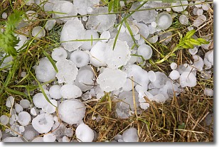
Hail is a form of precipitation which is recognized by large solid balls or
clumps of ice. Hail is created by thunderstorm clouds with strong updrafts of wind.
As the hailstones remain in the updraft, ice is deposited onto them until their
weight becomes heavy enough for them to fall to the earth's surface.
Hail storms can cause significant damage to crops, aircrafts, and man-made structures,
despite the fact that the duration is usually less than ten minutes.
Next Topic: Hole Punch Clouds
Weather Topic: What are Mammatus Clouds?
Home - Education - Cloud Types - Mammatus Clouds
 Next Topic: Nimbostratus Clouds
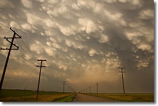
A mammatus cloud is a cloud with a unique feature which resembles
a web of pouches hanging along the base of the cloud.
In the United States, mammatus clouds tend to form in the warmer months, commonly
in the Midwest and eastern regions.
While they usually form at the bottom of a cumulonimbis cloud, they can also form
under altostratus, altocumulus, stratocumulus, and cirrus clouds. Mammatus clouds
warn that severe weather is close.
Next Topic: Nimbostratus Clouds
Current conditions powered by WeatherAPI.com


