Weather Alert in California
Winter Storm Watch issued February 13 at 12:41PM PST until February 18 at 4:00AM PST by NWS Medford OR
AREAS AFFECTED: South Central Siskiyou County; North Central and Southeast Siskiyou County
DESCRIPTION: * WHAT...Heavy snow possible. Total snow accumulations between 8 and 16 inches with up to 2 ft possible above 5000 ft. Winds could gust as high as 40 mph over high and exposed terrain. * WHERE...Southern and eastern Siskiyou County. This includes Highways 97 and 89, Interstate 5 south of Weed, Black Butte Summit, Snowman Summit, Dead Horse Summit, Grass Lake Summit and Mt Shasta Ski Park Road. This also includes the communities of Mt Shasta City, Dunsmuir, McCloud and Tennant. * WHEN...From Sunday evening through late Tuesday night. * IMPACTS...Travel may be very difficult to impossible. The hazardous conditions could impact the Monday morning and evening commutes. * ADDITIONAL DETAILS...Snow levels are expected to lower to 4500 ft Sunday night then down to 4000 ft Monday, but precipitation intensity will likely lower snow levels down to 3500 ft Monday. Snow levels lower further Monday night into Tuesday, possibly as low as 2000 ft by Tuesday morning.
INSTRUCTION: Monitor the latest forecasts for updates on this situation. People should consider delaying travel. If travel is absolutely necessary, drive with extreme caution. Take a winter storm kit with you that includes tire chains, booster cables, flashlight, shovel, blankets and extra clothing. Also take water, a first aid kit, and anything else that would help you survive in case you become stranded.
Want more detail? Get the Complete 7 Day and Night Detailed Forecast!
Current U.S. National Radar--Current
The Current National Weather Radar is shown below with a UTC Time (subtract 5 hours from UTC to get Eastern Time).

National Weather Forecast--Current
The Current National Weather Forecast and National Weather Map are shown below.

National Weather Forecast for Tomorrow
Tomorrow National Weather Forecast and Tomorrow National Weather Map are show below.

North America Water Vapor (Moisture)
This map shows recent moisture content over North America. Bright and colored areas show high moisture (ie, clouds); brown indicates very little moisture present; black indicates no moisture.

Weather Topic: What are Stratus Clouds?
Home - Education - Cloud Types - Stratus Clouds
 Next Topic: Wall Clouds
Stratus clouds are similar to altostratus clouds, but form at a
lower altitude and are identified by their fog-like appearance, lacking the
distinguishing features of most clouds.
Stratus clouds are wider than most clouds, and their base has a smooth, uniform
look which is lighter in color than a nimbostratus cloud.
The presence of a stratus cloud indicates the possibility of minor precipitation,
such as drizzle, but heavier precipitation does not typically arrive in the form
of a stratus cloud.
Next Topic: Wall Clouds
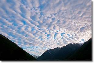
Weather Topic: What are Altocumulus Clouds?
Home - Education - Cloud Types - Altocumulus Clouds
 Next Topic: Altostratus Clouds
Similar to cirrocumulus clouds, altocumulus clouds are
characterized by cloud patches. They are distinguished by larger cloudlets
than cirrocumulus clouds but are still smaller than stratocumulus clouds.
Altocumulus clouds most commonly form in middle altitudes (between 2 and 5 km)
and may resemble, at times, the shape of a flying saucer.
These uncommon formations, called altocumulus lenticularis, are created by uplift
in the atmosphere and are most often seen in close proximity to mountains.
Next Topic: Altostratus Clouds
Current conditions powered by WeatherAPI.com


