Weather Alert in New Mexico
Fire Weather Watch issued March 29 at 1:58PM MDT until March 30 at 8:00PM MDT by NWS Albuquerque NM
AREAS AFFECTED: Northeast Plains; Northeast Highlands
DESCRIPTION: ...FIRE WEATHER WATCH FOR NORTHEASTERN NEW MEXICO MONDAY FROM NOON TO 8 PM MDT DUE TO GUSTY WINDS AND LOW HUMIDITY... .A lee-side surface trough will redevelop and deepen on Monday while fairly brisk winds aloft prevail. Above normal, and even record-breaking, temperatures will also develop with deep vertical mixing forecast through the afternoon. This will lead to gusty surface/20 ft winds as humidity plummets. There is some uncertainty that winds will be strong enough to meet traditional Red Flag criteria, but Energy Release Components (ERC's) are nearing historically high values, keeping at least a moderate (40-50%) chance of rapid fire spread. * AREA AND TIMING...Northeast Highlands (Zone 123) and the Northeast Plains (Zone 104) from noon through 8 PM MDT Monday. * 20 FOOT WINDS...Sustained winds of 15 to 20 mph from the west southwest with occasional gusts to 35 mph. * RELATIVE HUMIDITY...Falling to 9 to 12 percent by late afternoon. * IMPACTS...Any fires that develop will likely spread rapidly. Outdoor burning is not recommended.
INSTRUCTION: Please advise the appropriate officials or fire crews in the field of this Fire Weather Watch.
Want more detail? Get the Complete 7 Day and Night Detailed Forecast!
Current U.S. National Radar--Current
The Current National Weather Radar is shown below with a UTC Time (subtract 5 hours from UTC to get Eastern Time).

National Weather Forecast--Current
The Current National Weather Forecast and National Weather Map are shown below.

National Weather Forecast for Tomorrow
Tomorrow National Weather Forecast and Tomorrow National Weather Map are show below.

North America Water Vapor (Moisture)
This map shows recent moisture content over North America. Bright and colored areas show high moisture (ie, clouds); brown indicates very little moisture present; black indicates no moisture.

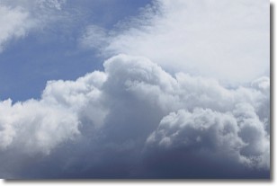
Weather Topic: What are Nimbostratus Clouds?
Home - Education - Cloud Types - Nimbostratus Clouds
 Next Topic: Precipitation
A nimbostratus cloud is similar to a stratus cloud in its formless,
smooth appearance. However, a nimbostratus cloud is darker than a stratus cloud,
because it is thicker.
Unlike a stratus cloud, a nimbostratus cloud typically brings with it the threat
of moderate to heavy precipitation. In some cases, the precipitation may evaporate
before reaching the ground, a phenomenon known as virga.
Next Topic: Precipitation
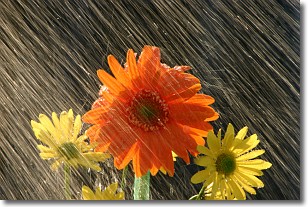
Weather Topic: What is Rain?
Home - Education - Precipitation - Rain
 Next Topic: Shelf Clouds
Precipitation in the form of water droplets is called rain.
Rain generally has a tendency to fall with less intensity over a greater period
of time, and when rainfall is more severe it is usually less sustained.
Rain is the most common form of precipitation and happens with greater frequency
depending on the season and regional influences. Cities have been shown to have
an observable effect on rainfall, due to an effect called the urban heat island.
Compared to upwind, monthly rainfall between twenty and forty miles downwind of
cities is 30% greater.
Next Topic: Shelf Clouds
Current conditions powered by WeatherAPI.com


