Weather Alert in Washington
Winter Weather Advisory issued March 9 at 1:42PM PDT until March 10 at 5:00PM PDT by NWS Seattle WA
AREAS AFFECTED: Cascades of Whatcom and Skagit Counties; Cascades of Snohomish and Northern King Counties
DESCRIPTION: * WHAT...For the Winter Storm Warning, heavy snow. Additional snow accumulations between 6 and 11 inches. For the Winter Weather Advisory, snow expected. Total snow accumulations between 2 and 4 inches. For the Blizzard Warning, blizzard conditions expected primarily Wednesday afternoon and evening. Winds gusting as high as 40 mph. Total snow accumulations between 2 and 4 feet possible. For the Winter Storm Watch, continued heavy snow is possible. * WHERE...Cascades of Snohomish and Northern King Counties and Cascades of Whatcom and Skagit Counties. * WHEN...For the Winter Storm Warning, until 5 AM PDT Tuesday. For the Winter Weather Advisory, from 5 AM to 5 PM PDT Tuesday. For the Blizzard Warning, from 5 PM Tuesday to 11 PM PDT Wednesday. The strongest winds will peak Wednesday evening into late Wednesday night. For the Winter Storm Watch, from Wednesday evening through Friday morning. * IMPACTS...Visibilities may drop below 1/4 mile due to falling and blowing snow. Travel could be very difficult to impossible. Gusty winds could bring down tree branches. * ADDITIONAL DETAILS...The strongest winds will occur over the passes on Wednesday evening into late Wednesday night.
INSTRUCTION: Travel should be restricted to emergencies only. If you must travel, have a winter survival kit with you. If you get stranded, stay with your vehicle. Prepare for possible power outages. Slow down and use caution while traveling. Prepare for possible power outages. Monitor the latest forecasts for updates on this situation. If you must travel, keep an extra flashlight, food, and water in your vehicle in case of an emergency. Prepare for possible power outages.
Want more detail? Get the Complete 7 Day and Night Detailed Forecast!
Current U.S. National Radar--Current
The Current National Weather Radar is shown below with a UTC Time (subtract 5 hours from UTC to get Eastern Time).

National Weather Forecast--Current
The Current National Weather Forecast and National Weather Map are shown below.

National Weather Forecast for Tomorrow
Tomorrow National Weather Forecast and Tomorrow National Weather Map are show below.

North America Water Vapor (Moisture)
This map shows recent moisture content over North America. Bright and colored areas show high moisture (ie, clouds); brown indicates very little moisture present; black indicates no moisture.

Weather Topic: What is Snow?
Home - Education - Precipitation - Snow
 Next Topic: Stratocumulus Clouds
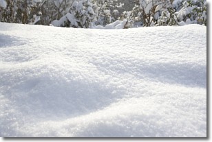
Snow is precipitation taking the form of ice crystals. Each ice crystal, or snowflake,
has unique characteristics, but all of them grow in a hexagonal structure.
Snowfall can last for sustained periods of time and result in significant buildup
of snow on the ground.
On the earth's surface, snow starts out light and powdery, but as it begins to melt
it tends to become more granular, producing small bits of ice which have the consistency of
sand. After several cycles of melting and freezing, snow can become very dense
and ice-like, commonly known as snow pack.
Next Topic: Stratocumulus Clouds
Weather Topic: What are Stratus Clouds?
Home - Education - Cloud Types - Stratus Clouds
 Next Topic: Wall Clouds
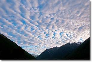
Stratus clouds are similar to altostratus clouds, but form at a
lower altitude and are identified by their fog-like appearance, lacking the
distinguishing features of most clouds.
Stratus clouds are wider than most clouds, and their base has a smooth, uniform
look which is lighter in color than a nimbostratus cloud.
The presence of a stratus cloud indicates the possibility of minor precipitation,
such as drizzle, but heavier precipitation does not typically arrive in the form
of a stratus cloud.
Next Topic: Wall Clouds
Current conditions powered by WeatherAPI.com


