Weather Alert in Washington
Blizzard Warning issued March 9 at 1:42PM PDT until March 11 at 11:00PM PDT by NWS Seattle WA
AREAS AFFECTED: Cascades of Southern King County; Cascades of Pierce and Lewis Counties
DESCRIPTION: * WHAT...For the Winter Weather Advisory, continued snow. Additional snow accumulations between 6 and 10 inches. For the Blizzard Warning, blizzard conditions expected. Winds gusting as high as 40 mph Wednesday evening into late Wednesday night. Total snow accumulations up to 2 feet. For the Winter Storm Watch, continuing heavy snow possible. Total snow accumulations up to 4 feet possible. * WHERE...Cascades of Pierce and Lewis Counties and Cascades of Southern King County. * WHEN...For the Winter Weather Advisory, until 5 PM PDT Tuesday. For the Blizzard Warning, from 5 PM Tuesday to 11 PM PDT Wednesday with the strongest winds peaking late Wednesday night. For the Winter Storm Watch, from Wednesday evening through Friday morning. * IMPACTS...Visibilities may drop below 1/4 mile due to falling and blowing snow. Travel could be very difficult to impossible. Gusty winds could bring down tree branches. * ADDITIONAL DETAILS...Lower elevations up to and including Snoqualmie Pass may transition over to rain late Wednesday as snow levels briefly rise before lowering again Thursday. The strongest winds will peak Wednesday evening into late Wednesday night.
INSTRUCTION: Travel should be restricted to emergencies only. If you must travel, have a winter survival kit with you. If you get stranded, stay with your vehicle. Prepare for possible power outages. Monitor the latest forecasts for updates on this situation. Slow down and use caution while traveling. Prepare for possible power outages.
Want more detail? Get the Complete 7 Day and Night Detailed Forecast!
Current U.S. National Radar--Current
The Current National Weather Radar is shown below with a UTC Time (subtract 5 hours from UTC to get Eastern Time).

National Weather Forecast--Current
The Current National Weather Forecast and National Weather Map are shown below.

National Weather Forecast for Tomorrow
Tomorrow National Weather Forecast and Tomorrow National Weather Map are show below.

North America Water Vapor (Moisture)
This map shows recent moisture content over North America. Bright and colored areas show high moisture (ie, clouds); brown indicates very little moisture present; black indicates no moisture.

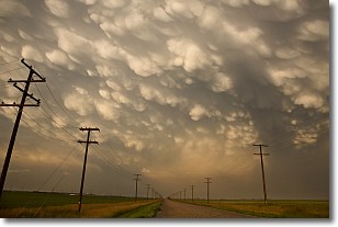
Weather Topic: What are Mammatus Clouds?
Home - Education - Cloud Types - Mammatus Clouds
 Next Topic: Nimbostratus Clouds
A mammatus cloud is a cloud with a unique feature which resembles
a web of pouches hanging along the base of the cloud.
In the United States, mammatus clouds tend to form in the warmer months, commonly
in the Midwest and eastern regions.
While they usually form at the bottom of a cumulonimbis cloud, they can also form
under altostratus, altocumulus, stratocumulus, and cirrus clouds. Mammatus clouds
warn that severe weather is close.
Next Topic: Nimbostratus Clouds
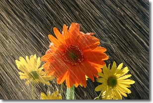
Weather Topic: What is Precipitation?
Home - Education - Precipitation - Precipitation
 Next Topic: Rain
Precipitation can refer to many different forms of water that
may fall from clouds. Precipitation occurs after a cloud has become saturated to
the point where its water particles are more dense than the air below the cloud.
In most cases, precipitation will reach the ground, but it is not uncommon for
precipitation to evaporate before it reaches the earth's surface.
When precipitation evaporates before it contacts the ground it is called Virga.
Graupel, hail, sleet, rain, drizzle, and snow are forms of precipitation, but fog
and mist are not considered precipitation because the water vapor which
constitutes them isn't dense enough to fall to the ground.
Next Topic: Rain
Current conditions powered by WeatherAPI.com


