Weather Alert in Washington
Winter Storm Watch issued March 9 at 1:42PM PDT until March 13 at 11:00AM PDT by NWS Seattle WA
AREAS AFFECTED: Cascades of Southern King County; Cascades of Pierce and Lewis Counties
DESCRIPTION: * WHAT...For the Winter Weather Advisory, continued snow. Additional snow accumulations between 6 and 10 inches. For the Blizzard Warning, blizzard conditions expected. Winds gusting as high as 40 mph Wednesday evening into late Wednesday night. Total snow accumulations up to 2 feet. For the Winter Storm Watch, continuing heavy snow possible. Total snow accumulations up to 4 feet possible. * WHERE...Cascades of Pierce and Lewis Counties and Cascades of Southern King County. * WHEN...For the Winter Weather Advisory, until 5 PM PDT Tuesday. For the Blizzard Warning, from 5 PM Tuesday to 11 PM PDT Wednesday with the strongest winds peaking late Wednesday night. For the Winter Storm Watch, from Wednesday evening through Friday morning. * IMPACTS...Visibilities may drop below 1/4 mile due to falling and blowing snow. Travel could be very difficult to impossible. Gusty winds could bring down tree branches. * ADDITIONAL DETAILS...Lower elevations up to and including Snoqualmie Pass may transition over to rain late Wednesday as snow levels briefly rise before lowering again Thursday. The strongest winds will peak Wednesday evening into late Wednesday night.
INSTRUCTION: Travel should be restricted to emergencies only. If you must travel, have a winter survival kit with you. If you get stranded, stay with your vehicle. Prepare for possible power outages. Monitor the latest forecasts for updates on this situation. Slow down and use caution while traveling. Prepare for possible power outages.
Want more detail? Get the Complete 7 Day and Night Detailed Forecast!
Current U.S. National Radar--Current
The Current National Weather Radar is shown below with a UTC Time (subtract 5 hours from UTC to get Eastern Time).

National Weather Forecast--Current
The Current National Weather Forecast and National Weather Map are shown below.

National Weather Forecast for Tomorrow
Tomorrow National Weather Forecast and Tomorrow National Weather Map are show below.

North America Water Vapor (Moisture)
This map shows recent moisture content over North America. Bright and colored areas show high moisture (ie, clouds); brown indicates very little moisture present; black indicates no moisture.

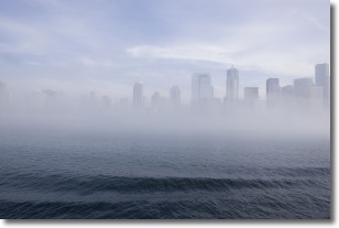
Weather Topic: What is Fog?
Home - Education - Cloud Types - Fog
 Next Topic: Fractus Clouds
Fog is technically a type of stratus cloud, which lies along the
ground and obscures visibility.
It is usually created when humidity in the air condenses into tiny water droplets.
Because of this, some places are more prone to foggy weather, such as regions
close to a body of water.
Fog is similar to mist; both are the appearance of water droplets suspended in
the air, but fog is the term applied to the condition when visibility is less than 1 km.
Next Topic: Fractus Clouds
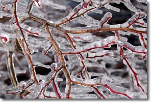
Weather Topic: What is Freezing Rain?
Home - Education - Precipitation - Freezing Rain
 Next Topic: Graupel
Freezing rain is a condition where precipitation which has fallen in the form of
water droplets reaches temperatures which are below freezing and freezes upon
coming into contact
with surface objects. The result of this precipitation is a glaze of ice which
can be damaging to plants and man-made structures. A severe onset of freezing
rain which results in a very thick glaze of ice is known as an ice storm.
Next Topic: Graupel
Current conditions powered by WeatherAPI.com


