Weather Alert in Kansas
Flood Warning issued February 15 at 7:51AM CST until February 16 at 9:00AM CST by NWS Topeka KS
AREAS AFFECTED: Franklin, KS
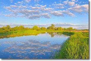
DESCRIPTION: * WHAT...Flooding caused by the Marais Des Cygnes River rising above flood stage of 20 feet. * WHERE...A portion of east central Kansas, including the following county, Franklin. * WHEN...Until 900 AM CST Monday. * IMPACTS...Flooding of the Marais Des Cygnes River, northeast of Pomona will continue through the mid morning hours of Monday. * ADDITIONAL DETAILS... - At 747 AM CST, Flooding is occurring along the Marais Des Cygnes River bank northeast of Pomona. - At 730 AM CST, the Marais Des Cygnes River, northeast of Pomona was at 22.39 feet and may crest around 24 feet this afternoon. - Some locations that will experience flooding include... mainly rural areas of Western Franklin County along the Marais Des Cygnes river northeast of Pomona.
INSTRUCTION: Turn around, don't drown when encountering flooded roads. Most flood deaths occur in vehicles.
Want more detail? Get the Complete 7 Day and Night Detailed Forecast!
Current U.S. National Radar--Current
The Current National Weather Radar is shown below with a UTC Time (subtract 5 hours from UTC to get Eastern Time).

National Weather Forecast--Current
The Current National Weather Forecast and National Weather Map are shown below.

National Weather Forecast for Tomorrow
Tomorrow National Weather Forecast and Tomorrow National Weather Map are show below.

North America Water Vapor (Moisture)
This map shows recent moisture content over North America. Bright and colored areas show high moisture (ie, clouds); brown indicates very little moisture present; black indicates no moisture.

Weather Topic: What are Stratocumulus Clouds?
Home - Education - Cloud Types - Stratocumulus Clouds
 Next Topic: Stratus Clouds
Stratocumulus clouds are similar to altocumulus clouds in their
fluffy appearance, but have a slightly darker shade due to their additional mass.
A good way to distinguish the two cloud types is to hold your hand out and measure
the size of an individual cloud; if it is the size of your thumb it is generally
an altocumulus cloud, if it is the size of your hand it is generally a
stratocumulus cloud.
It is uncommon for stratocumulus clouds to produce precipitation, but if they do
it is usually a light rain or snow.
Next Topic: Stratus Clouds
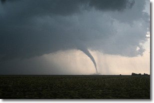
Weather Topic: What are Wall Clouds?
Home - Education - Cloud Types - Wall Clouds
 Next Topic: Altocumulus Clouds
A wall cloud forms underneath the base of a cumulonimbus cloud,
and can be a hotbed for deadly tornadoes.
Wall clouds are formed by air flowing into the cumulonimbus clouds, which can
result in the wall cloud descending from the base of the cumulonimbus cloud, or
rising fractus clouds which join to the base of the storm cloud as the wall cloud
takes shape.
Wall clouds can be very large, and in the Northern Hemisphere they generally
form at the southern edge of cumulonimbus clouds.
Next Topic: Altocumulus Clouds
Current conditions powered by WeatherAPI.com


