Weather Alert in Nebraska
Flood Watch issued February 8 at 11:20AM CST until February 9 at 10:00PM CST by NWS Omaha/Valley NE
AREAS AFFECTED: Antelope; Pierce; Madison; Stanton; Cuming; Platte; Colfax; Dodge; Washington; Butler; Saunders; Douglas; Sarpy; Cass
DESCRIPTION: A watch remains in effect for the Platte, Elkhorn and Loup rivers due to potential ice jam development. This heightened threat is due to persistent warm weather. Those with interests along area rivers, especially in low-lying areas, should remain vigilant to the potential for rapidly rising water. * WHAT...Flooding caused by an ice jam continues to be possible. * WHERE...Portions of east central, northeast, and southeast Nebraska, including the following counties, in east central Nebraska, Butler, Dodge, Douglas, Sarpy, Saunders and Washington. In northeast Nebraska, Antelope, Colfax, Cuming, Madison, Pierce, Platte and Stanton. In southeast Nebraska, Cass. * WHEN...Through Monday evening. * IMPACTS...The formation of an ice jam could result in sudden rises of water, leading to a rapid flooding situation. Ice jams can cause water level fluctuations of 1 to 3 feet over a very short time period and without much notice. * ADDITIONAL DETAILS... - While no ice movement has been observed or reported, several consecutive days of highs ranging from the upper 40s to mid 60s suggest breakup and movement is imminent.
INSTRUCTION: You should monitor later forecasts and be alert for possible Flood Warnings. Those living in areas prone to flooding should be prepared to take action should flooding develop.
Want more detail? Get the Complete 7 Day and Night Detailed Forecast!
Current U.S. National Radar--Current
The Current National Weather Radar is shown below with a UTC Time (subtract 5 hours from UTC to get Eastern Time).

National Weather Forecast--Current
The Current National Weather Forecast and National Weather Map are shown below.

National Weather Forecast for Tomorrow
Tomorrow National Weather Forecast and Tomorrow National Weather Map are show below.

North America Water Vapor (Moisture)
This map shows recent moisture content over North America. Bright and colored areas show high moisture (ie, clouds); brown indicates very little moisture present; black indicates no moisture.

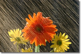
Weather Topic: What is Rain?
Home - Education - Precipitation - Rain
 Next Topic: Shelf Clouds
Precipitation in the form of water droplets is called rain.
Rain generally has a tendency to fall with less intensity over a greater period
of time, and when rainfall is more severe it is usually less sustained.
Rain is the most common form of precipitation and happens with greater frequency
depending on the season and regional influences. Cities have been shown to have
an observable effect on rainfall, due to an effect called the urban heat island.
Compared to upwind, monthly rainfall between twenty and forty miles downwind of
cities is 30% greater.
Next Topic: Shelf Clouds
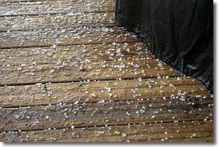
Weather Topic: What is Sleet?
Home - Education - Precipitation - Sleet
 Next Topic: Snow
Sleet is a form of precipitation in which small ice pellets are the primary
components. These ice pellets are smaller and more translucent than hailstones,
and harder than graupel. Sleet is caused by specific atmospheric conditions and
therefore typically doesn't last for extended periods of time.
The condition which leads to sleet formation requires a warmer body of air to be
wedged in between two sub-freezing bodies of air. When snow falls through a warmer
layer of air it melts, and as it falls through the next sub-freezing body of air
it freezes again, forming ice pellets known as sleet. In some cases, water
droplets don't have time to freeze before reaching the surface and the result is
freezing rain.
Next Topic: Snow
Current conditions powered by WeatherAPI.com


