Weather Alert in Kansas
Fire Weather Watch issued February 16 at 2:53AM CST until February 17 at 7:00PM CST by NWS Topeka KS
AREAS AFFECTED: Republic; Washington; Marshall; Nemaha; Brown; Cloud; Clay; Riley; Pottawatomie; Jackson; Jefferson; Ottawa; Dickinson; Geary; Morris; Wabaunsee; Shawnee; Douglas; Lyon; Osage; Franklin; Coffey; Anderson
DESCRIPTION: ...FIRE WEATHER WATCH IN EFFECT FROM NOON THROUGH 7 PM TUESDAY... The National Weather Service in Topeka has issued a Fire Weather Watch for low relative humidity, strong wind gusts, and dry dormant fuels, which is in effect from Tuesday afternoon through Tuesday evening. * AFFECTED AREA...Fire Weather Zone 008 Republic, Fire Weather Zone 009 Washington, Fire Weather Zone 010 Marshall, Fire Weather Zone 011 Nemaha, Fire Weather Zone 012 Brown, Fire Weather Zone 020 Cloud, Fire Weather Zone 021 Clay, Fire Weather Zone 022 Riley, Fire Weather Zone 023 Pottawatomie, Fire Weather Zone 024 Jackson, Fire Weather Zone 026 Jefferson, Fire Weather Zone 034 Ottawa, Fire Weather Zone 035 Dickinson, Fire Weather Zone 036 Geary, Fire Weather Zone 037 Morris, Fire Weather Zone 038 Wabaunsee, Fire Weather Zone 039 Shawnee, Fire Weather Zone 040 Douglas, Fire Weather Zone 054 Lyon, Fire Weather Zone 055 Osage, Fire Weather Zone 056 Franklin, Fire Weather Zone 058 Coffey and Fire Weather Zone 059 Anderson. * TIMING...From Tuesday afternoon through Tuesday evening. * WINDS...South 20 to 30 mph with gusts up to 45 mph. * RELATIVE HUMIDITY...20 to 35 percent. * TEMPERATURES...Up to 77. * IMPACTS...Any fire that develops will catch and spread quickly. Outdoor burning is not recommended.
INSTRUCTION: A Fire Weather Watch means that critical fire weather conditions are forecast to occur. Listen for later forecasts and possible Red Flag Warnings.
Want more detail? Get the Complete 7 Day and Night Detailed Forecast!
Current U.S. National Radar--Current
The Current National Weather Radar is shown below with a UTC Time (subtract 5 hours from UTC to get Eastern Time).

National Weather Forecast--Current
The Current National Weather Forecast and National Weather Map are shown below.

National Weather Forecast for Tomorrow
Tomorrow National Weather Forecast and Tomorrow National Weather Map are show below.

North America Water Vapor (Moisture)
This map shows recent moisture content over North America. Bright and colored areas show high moisture (ie, clouds); brown indicates very little moisture present; black indicates no moisture.

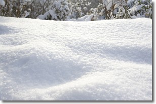
Weather Topic: What is Snow?
Home - Education - Precipitation - Snow
 Next Topic: Stratocumulus Clouds
Snow is precipitation taking the form of ice crystals. Each ice crystal, or snowflake,
has unique characteristics, but all of them grow in a hexagonal structure.
Snowfall can last for sustained periods of time and result in significant buildup
of snow on the ground.
On the earth's surface, snow starts out light and powdery, but as it begins to melt
it tends to become more granular, producing small bits of ice which have the consistency of
sand. After several cycles of melting and freezing, snow can become very dense
and ice-like, commonly known as snow pack.
Next Topic: Stratocumulus Clouds
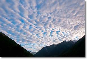
Weather Topic: What are Stratus Clouds?
Home - Education - Cloud Types - Stratus Clouds
 Next Topic: Wall Clouds
Stratus clouds are similar to altostratus clouds, but form at a
lower altitude and are identified by their fog-like appearance, lacking the
distinguishing features of most clouds.
Stratus clouds are wider than most clouds, and their base has a smooth, uniform
look which is lighter in color than a nimbostratus cloud.
The presence of a stratus cloud indicates the possibility of minor precipitation,
such as drizzle, but heavier precipitation does not typically arrive in the form
of a stratus cloud.
Next Topic: Wall Clouds
Current conditions powered by WeatherAPI.com


