Weather Alert in Ohio
Tornado Watch issued March 7 at 1:23PM EST until March 7 at 8:00PM EST by NWS Pittsburgh PA
AREAS AFFECTED: Belmont, OH; Carroll, OH; Columbiana, OH; Coshocton, OH; Guernsey, OH; Harrison, OH; Jefferson, OH; Monroe, OH; Muskingum, OH; Noble, OH; Tuscarawas, OH; Allegheny, PA; Armstrong, PA; Beaver, PA; Butler, PA; Clarion, PA; Fayette, PA; Forest, PA; Greene, PA; Indiana, PA; Jefferson, PA; Lawrence, PA; Mercer, PA; Venango, PA; Washington, PA; Westmoreland, PA; Brooke, WV; Hancock, WV; Marion, WV; Marshall, WV; Monongalia, WV; Ohio, WV; Preston, WV; Wetzel, WV
DESCRIPTION: THE NATIONAL WEATHER SERVICE HAS ISSUED TORNADO WATCH 25 IN EFFECT UNTIL 8 PM EST THIS EVENING FOR THE FOLLOWING AREAS IN OHIO THIS WATCH INCLUDES 11 COUNTIES IN EAST CENTRAL OHIO BELMONT CARROLL COLUMBIANA COSHOCTON GUERNSEY HARRISON JEFFERSON OH MONROE MUSKINGUM NOBLE TUSCARAWAS IN PENNSYLVANIA THIS WATCH INCLUDES 15 COUNTIES IN NORTHWEST PENNSYLVANIA FOREST MERCER VENANGO IN SOUTHWEST PENNSYLVANIA ALLEGHENY FAYETTE GREENE WASHINGTON WESTMORELAND IN WEST CENTRAL PENNSYLVANIA ARMSTRONG BUTLER CLARION INDIANA JEFFERSON PA IN WESTERN PENNSYLVANIA BEAVER LAWRENCE IN WEST VIRGINIA THIS WATCH INCLUDES 8 COUNTIES IN NORTHEAST WEST VIRGINIA PRESTON IN NORTHERN WEST VIRGINIA MARION MONONGALIA WETZEL IN THE NORTHERN PANHANDLE OF WEST VIRGINIA BROOKE HANCOCK MARSHALL OHIO THIS INCLUDES THE CITIES OF ALIQUIPPA, AMBRIDGE, BEAVER FALLS, BROOKVILLE, BUTLER, CADIZ, CALDWELL, CAMBRIDGE, CANONSBURG, CARROLLTON, CLARION, COLUMBIANA, CONNELLSVILLE, COSHOCTON, DOVER, EAST LIVERPOOL, ELLWOOD CITY, FAIRMONT, FOLLANSBEE, FORD CITY, FRANKLIN, GREENSBURG, GROVE CITY, HERMITAGE, INDIANA, KINGWOOD, KITTANNING, LATROBE, MARTINS FERRY, MASONTOWN, MONACA, MORGANTOWN, MOUNDSVILLE, MURRYSVILLE, NEW CASTLE, NEW KENSINGTON, NEW MARTINSVILLE, NEW PHILADELPHIA, OIL CITY, PITTSBURGH METRO AREA, PUNXSUTAWNEY, SALEM, SHARON, ST. CLAIRSVILLE, STEUBENVILLE, TERRA ALTA, TIONESTA, UNIONTOWN, WASHINGTON, WAYNESBURG, WEIRTON, WELLSBURG, WHEELING, WOODSFIELD, AND ZANESVILLE.
INSTRUCTION: N/A
Want more detail? Get the Complete 7 Day and Night Detailed Forecast!
Current U.S. National Radar--Current
The Current National Weather Radar is shown below with a UTC Time (subtract 5 hours from UTC to get Eastern Time).

National Weather Forecast--Current
The Current National Weather Forecast and National Weather Map are shown below.

National Weather Forecast for Tomorrow
Tomorrow National Weather Forecast and Tomorrow National Weather Map are show below.

North America Water Vapor (Moisture)
This map shows recent moisture content over North America. Bright and colored areas show high moisture (ie, clouds); brown indicates very little moisture present; black indicates no moisture.

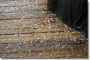
Weather Topic: What is Sleet?
Home - Education - Precipitation - Sleet
 Next Topic: Snow
Sleet is a form of precipitation in which small ice pellets are the primary
components. These ice pellets are smaller and more translucent than hailstones,
and harder than graupel. Sleet is caused by specific atmospheric conditions and
therefore typically doesn't last for extended periods of time.
The condition which leads to sleet formation requires a warmer body of air to be
wedged in between two sub-freezing bodies of air. When snow falls through a warmer
layer of air it melts, and as it falls through the next sub-freezing body of air
it freezes again, forming ice pellets known as sleet. In some cases, water
droplets don't have time to freeze before reaching the surface and the result is
freezing rain.
Next Topic: Snow
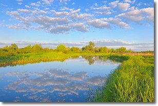
Weather Topic: What are Stratocumulus Clouds?
Home - Education - Cloud Types - Stratocumulus Clouds
 Next Topic: Stratus Clouds
Stratocumulus clouds are similar to altocumulus clouds in their
fluffy appearance, but have a slightly darker shade due to their additional mass.
A good way to distinguish the two cloud types is to hold your hand out and measure
the size of an individual cloud; if it is the size of your thumb it is generally
an altocumulus cloud, if it is the size of your hand it is generally a
stratocumulus cloud.
It is uncommon for stratocumulus clouds to produce precipitation, but if they do
it is usually a light rain or snow.
Next Topic: Stratus Clouds
Current conditions powered by WeatherAPI.com


