Weather Alert in New Mexico
High Wind Watch issued February 15 at 9:21PM MST until February 17 at 11:00PM MST by NWS El Paso Tx/Santa Teresa NM
AREAS AFFECTED: Sacramento Mountains Above 7500 Feet; East Slopes Sacramento Mountains Below 7500 Feet
DESCRIPTION: * WHAT...For Tuesday's High Wind Watch, west winds 35 to 45 mph with gusts up to 70 mph possible. For the Wednesday's High Wind Watch, west winds 30 to 40 mph with gusts up to 65 mph possible. * WHERE...East Slopes Sacramento Mountains Below 7500 Feet and Sacramento Mountains Above 7500 Feet. * WHEN...For the first High Wind Watch, from Tuesday morning through Tuesday evening. For the second High Wind Watch, from Wednesday afternoon through Wednesday evening. * IMPACTS...Strong winds may damage trees and power lines. Driving will be difficult for north-south roads, especially for high-profile vehicles.
INSTRUCTION: Monitor the latest forecasts and warnings for updates.
Want more detail? Get the Complete 7 Day and Night Detailed Forecast!
Current U.S. National Radar--Current
The Current National Weather Radar is shown below with a UTC Time (subtract 5 hours from UTC to get Eastern Time).

National Weather Forecast--Current
The Current National Weather Forecast and National Weather Map are shown below.

National Weather Forecast for Tomorrow
Tomorrow National Weather Forecast and Tomorrow National Weather Map are show below.

North America Water Vapor (Moisture)
This map shows recent moisture content over North America. Bright and colored areas show high moisture (ie, clouds); brown indicates very little moisture present; black indicates no moisture.

Weather Topic: What is Snow?
Home - Education - Precipitation - Snow
 Next Topic: Stratocumulus Clouds
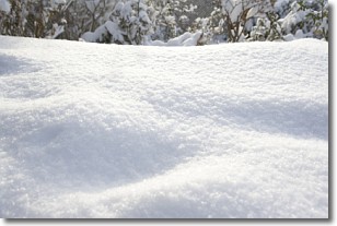
Snow is precipitation taking the form of ice crystals. Each ice crystal, or snowflake,
has unique characteristics, but all of them grow in a hexagonal structure.
Snowfall can last for sustained periods of time and result in significant buildup
of snow on the ground.
On the earth's surface, snow starts out light and powdery, but as it begins to melt
it tends to become more granular, producing small bits of ice which have the consistency of
sand. After several cycles of melting and freezing, snow can become very dense
and ice-like, commonly known as snow pack.
Next Topic: Stratocumulus Clouds
Weather Topic: What are Stratus Clouds?
Home - Education - Cloud Types - Stratus Clouds
 Next Topic: Wall Clouds
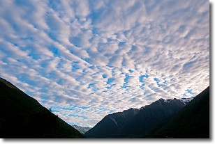
Stratus clouds are similar to altostratus clouds, but form at a
lower altitude and are identified by their fog-like appearance, lacking the
distinguishing features of most clouds.
Stratus clouds are wider than most clouds, and their base has a smooth, uniform
look which is lighter in color than a nimbostratus cloud.
The presence of a stratus cloud indicates the possibility of minor precipitation,
such as drizzle, but heavier precipitation does not typically arrive in the form
of a stratus cloud.
Next Topic: Wall Clouds
Current conditions powered by WeatherAPI.com


