Weather Alert in California
Flood Warning issued February 24 at 2:52PM PST until February 25 at 11:00AM PST by NWS Eureka CA
AREAS AFFECTED: Humboldt, CA
DESCRIPTION: ...The Flood Warning is extended for the following rivers in California... Eel River at Fernbridge affecting Humboldt County. For the Eel River...including Fernbridge, Scotia, Bridgeville, Fort Seward, Miranda...Minor flooding is forecast. * WHAT...Minor flooding is forecast. * WHERE...Eel River at Fernbridge. * WHEN...From this evening to Wednesday morning. * IMPACTS...At 20.0 feet, Significant flooding of the western portions of Cannibal Island Road, Camp Weott Road, the Salt and Old Rivers, and all adjacent low-lying areas. Flooding in these areas is exaggerated when crest timing is coincident with high tides and strong onshore winds, and for longer duration events. A Special Action Advisory is being issued to all owners of livestock in low-lying areas of the Eel Delta. Owners of livestock should consider taking appropriate action to protect livestock. At 22.0 feet, The western half of the Eel Delta may be completely flooded, especially if at or above this level for an extended period of time. This includes areas northwest of Loleta and Cannibal Island Road. A Special Action Advisory is being issued to all owners of livestock in low-lying areas of the Eel River Delta. Owners of livestock should take appropriate action to protect their animals. * ADDITIONAL DETAILS... - At 2:15 PM PST Tuesday the stage was 12.8 feet. - Bankfull stage is 20.0 feet. - Forecast...The river is expected to rise above flood stage late this evening to a crest of 21.9 feet late tonight. It will then fall below flood stage late tomorrow morning. - Flood stage is 20.0 feet. - Flood History...This crest compares to a previous crest of 21.9 feet on 03/18/1975. - http://www.weather.gov/safety/flood
INSTRUCTION: Turn around, don't drown when encountering flooded roads. Most flood deaths occur in vehicles. Motorists should not attempt to drive around barricades or drive cars through flooded areas. Stay tuned to further developments by listening to your local radio, television, or NOAA Weather Radio for further information. Be especially cautious at night when it is harder to recognize the dangers of flooding. This warning will be in effect until the river falls below its flood stage. Please report observed flooding to local emergency services or law enforcement and request they pass this information to the National Weather Service when you can do so safely. Additional information is available at weather.gov/eka. The next statement will be issued late tonight at 300 AM PST.
Want more detail? Get the Complete 7 Day and Night Detailed Forecast!
Current U.S. National Radar--Current
The Current National Weather Radar is shown below with a UTC Time (subtract 5 hours from UTC to get Eastern Time).

National Weather Forecast--Current
The Current National Weather Forecast and National Weather Map are shown below.

National Weather Forecast for Tomorrow
Tomorrow National Weather Forecast and Tomorrow National Weather Map are show below.

North America Water Vapor (Moisture)
This map shows recent moisture content over North America. Bright and colored areas show high moisture (ie, clouds); brown indicates very little moisture present; black indicates no moisture.

Weather Topic: What is Condensation?
Home - Education - Precipitation - Condensation
 Next Topic: Contrails
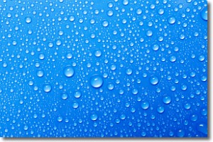
Condensation is the process which creates clouds, and therefore
it is a crucial process in the water cycle.
Condensation is the change of matter from a state of gas into a state of liquid,
and it happens because water molecules release heat into the atmosphere and
become organized into a more closely packed structure, what we might see as
water droplets.
Water is always present in the air around us as a vapor, but it's too small for
us to see. When water undergoes the process of condensation it becomes organized
into visible water droplets. You've probably seen condensation happen before on the
surface of a cold drink!
Next Topic: Contrails
Weather Topic: What are Cumulonimbus Clouds?
Home - Education - Cloud Types - Cumulonimbus Clouds
 Next Topic: Cumulus Clouds
The final form taken by a growing cumulus cloud is the
cumulonimbus cloud, which is very tall and dense.
The tower of a cumulonimbus cloud can soar 23 km into the atmosphere, although
most commonly they stop growing at an altitude of 6 km.
Even small cumulonimbus clouds appear very large in comparison to other cloud types.
They can signal the approach of stormy weather, such as thunderstorms or blizzards.
Next Topic: Cumulus Clouds
Current conditions powered by WeatherAPI.com


